Click to visit the main New York Public Library Homepage
The New York Public Library
Digital Collections
About Digital Collections
Browse
Search only public domain materials
Items
Collections
Divisions
Home
Search
Browse
About
Search only public domain materials
Items
Collections
Divisions
Digital Collections
Using Images
Using Data
Search
Filtered keyword search
Show filters
Hide filters
Show Only Public Domain
topic
Real property
77
Landowners
61
Cities and towns
11
Administrative and political divisions
10
Villages
7
More
Less
name
Worley & Bracher
8
Bourquin, F. (Frederick), 1808-
5
Hotchkiss, Jedediah, 1828-1899
4
Michie, Peter Smith, 1839-1901
4
Smith, Robert Pearsall, 1827-1898
4
More
Less
collection
Maps of North America
75
Maps of New York City and State
8
Atlases of New York City
1
Atlases of the United States
1
Collection of broadside real estate maps announcing auctions of lots in early 19th century New York City
1
place
Pennsylvania
24
Ohio
11
New York (State)
9
Virginia
9
Wisconsin
8
More
Less
genre
x
Cadastral maps
Maps
86
Illustrations
8
Charts
2
Topographic maps
2
More
Less
publisher
publisher not identified
14
Published by authority of the Hon. the Secretary of War, Office of the Chief of Engineers, U.S. Army
4
A. Pomeroy
2
G. Wm. Baist, Map Publisher
2
Lee & Marsh
2
More
Less
division
Map Division
85
Milstein Division
1
type
x
cartographic
still image
10
text
1
Date Range
to
86 results found for:
x
17
Filtering on:
x
Genre
: Cadastral maps
x
Type
: cartographic
Sort by:
Relevance
Title
Date created
Date digitized
Sequence
m
Wright's map of Kansas City, …
Map of the flats above Albany
… Page Plate No.
17
[Map
Plate
17
: Bounded by Bowery Bay Road, Shore
m
Map of Hennepin County, Minne…
note:
… Division, v. 5, page
17
m
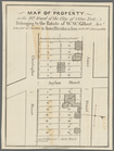
Map of the property of the Yo…
note:
…"Dec.
17
, 1890; For information apply to Alfred
Part of Wards 3 & 4, Yonkers
note:
…. Robinson, 1889. plate
17
.
m
Map of Elizabeth City Co., Va…
first:
e
17
c9710-537f-0135-9cf3-39e97f969568
m
A topographical map of Lincol…
Map of Sullivan County, New Y…
Map of Orange County, Florida
m
Map of Tioga County, New York…
m
A topographical map of Lincol…
A topographical map of Steube…
m
Map of Trumbull County, Ohio
m
Map of Rockingham Co., New Ha…
m
Map of property in the 9th wa…
Information map, Hd. Qrs. 20 …
Map of Great Barn Island, New…
Map of the oil region, Venang…
Map of Chattanooga, Tenn.
Plat of the private claims at…
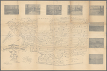
A plan of the land belonging …
Whitesboro, Brown Co., W.T.
A plan of the town of Pittsfo…
Map of lands belonging to Jam…
Map of the city of Erie : sho…
Lands of the Tremont Petroleu…
Map of Baker City, Oregon
Map of the Melrose addition t…
Map of Warren County, Pennsyl…
New Castle, Virginia, Series …
Map of Venango County oil reg…
Plan of President Township
Map of Greene County, Virgini…
parent:
4e9514a0-5a86-0135-bd86-0332d07d
17
de
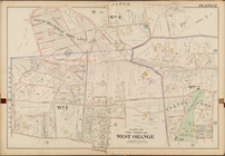
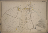
Map of the city of Tacoma : P…
m
Superior, Douglas County, Wis…
Map of Rappahannock County, V…
Map of Augusta County, Virgin…
m
Map of the city and suburbs o…
Map of property of the Bloomi…
Superior, Douglass County, Wi…
Map of Madison County, Virgin…
Map of St. Joseph, Mo. and vi…
Map of St. Joseph, Mo. and vi…
Plan des achats des compagnie…
m
Map of Mahoning County, Ohio …
m
City of Toledo, Lucas Co., Oh…
Map of West Hickory Creek, Ve…
m
Map of Charlotte, Mecklenberg…