Click to visit the main New York Public Library Homepage
The New York Public Library
Digital Collections
About Digital Collections
Browse
Search only public domain materials
Items
Collections
Divisions
Home
Search
Browse
About
Search only public domain materials
Items
Collections
Divisions
Digital Collections
Using Images
Using Data
Search
Filtered keyword search
Show filters
Hide filters
Show Only Public Domain
topic
Real property
43
Landowners
40
Cities and towns
13
Villages
13
Administrative and political divisions
6
More
Less
name
Smith, Robert Pearsall, 1827-1898
9
Worley & Bracher
6
Beers, D. G. (Daniel G.)
5
Bourquin, F. (Frederick), 1808-
5
Walling, Henry Francis, 1825-1888
5
More
Less
collection
Maps of New York City and State
23
Maps of North America
22
place
New York (State)
23
Pennsylvania
6
Massachusetts
4
Kentucky
3
Seneca County
3
More
Less
genre
x
Cadastral maps
Maps
45
Illustrations
4
Pictorial works
2
Advertisements
1
More
Less
publisher
publisher not identified
4
Smith, Gallup & Co
3
A. Pomeroy
2
Beers & Lanagan
2
Publisher not identified
2
More
Less
division
Map Division
45
type
cartographic
45
still image
6
Date Range
to
45 results found for:
x
Tables
Filtering on:
x
Genre
: Cadastral maps
Sort by:
Relevance
Title
Date created
Date digitized
Sequence
Chase's ice map, showing loca…
note:
… advertisements,
tables
of ice measurements, and
tables
of ice
Map of lands in the town of Y…
note:
Includes recapitulation
tables
.
m
Map of the City of Utica, One…
note:
Includes statistical
tables
and local
Map of La Presa : San Diego C…
abstract:
…., and
tables
.
m
Map of Washington County, New…
abstract:
… statistical
tables
, 16
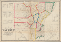
Map of Warren Co., New York
note:
Includes statistical
tables
, and insets
m
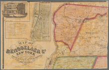
Map of Rensselaer County, New…
note:
Includes statistical
tables
, local
m
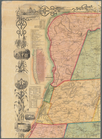
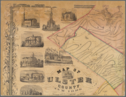
Map of Ulster County, New York
note:
Includes notes, statistical
tables
, 2 inset
m
Map of Tioga County, New York…
note:
Includes statistical
tables
, indexed
m
Map of Ulster County, New York
abstract:
…, statistical
tables
, 3 inset
m
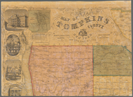
Map of Tompkins County, New Y…
note:
Includes statistical
tables
, local
m
Map of Trumbull County, Ohio
abstract:
…
table
, business
m
Map of Orange and Rockland Co…
note:
Also Includes
table
Topographical map of Seneca C…
note:
… of 1850 statistical
table
, "Village statistics"
table
Map of Broome County, New York
note:
…, county statistical
table
, distance
table
, inset "Map
m
Map of Fulton Co., Pennsylvan…
abstract:
… directories, "
Table
of air
m
Map of Suffolk Co., L.I., New…
note:
… statistical
table
, distance
table
, local business
Map of part of Monroe County,…
abstract:
… and index or
table
showing
m
Map of Lebanon County, Pennsy…
abstract:
…
table
, distance
table
Block sketch 1679, New York C…
note:
Includes
table
listing numbers
Plan of land & water lots of …
note:
Includes
table
of property dimensions
Map of the mouth of St. Clair…
abstract:
… index or
table
showing
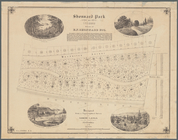
Shonnard Park at Yonkers, est…
note:
Includes text,
table
of plot acreages
Map of St. Joseph, Mo. and vi…
abstract:
…, and
table
"[A few] facts
m
Map of Dutchess Co., New York…
abstract:
… statistical
table
, 33 village
m
Map of Columbiana County, Ohi…
abstract:
…, statistical
table
m
Map of Bedford County, Pa.
abstract:
… county statistical
table
Map of Richland, Oswego Co. N…
note:
Includes historical note, statistical
table
m
Map of Scott Co., Kentucky : …
abstract:
…, population
table
, and 4 inset
m
Map of Montgomery County, Ken…
abstract:
…, population
table
, and 4 inset
m
Map of Rensselaer Co., New Yo…
note:
Includes a
table
of distances, local business
Map of Seneca County, New Yor…
note:
Includes population statistical
table
, bar scale
A topographical map of Steube…
note:
Includes population statistical
table
, local
m
Map of Christian County, Ky. …
abstract:
…, population
table
, and insets
m
Map of New London County, Con…
note:
Includes
table
of distances, populations
m
Map of Cayuga and Seneca Coun…
note:
Includes distance
table
, local business
m
Map of Somerset County, Pa.
abstract:
…, "Statistical
table
of Somerset
m
Gillette's map of Oneida Co.,…
note:
… buildings, and
table
Map of Franklin County, Massa…
note:
…, and population; and
Table
m
Map of the county of Berkshir…
note:
… census), and
table
Map of the county of Berkshir…
note:
… census of 1855,"
table
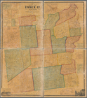
Map of Essex Co., New York
note:
… Mtn.; and
table
m
Topographical map of the coun…
abstract:
… by hachures. Includes
table
m
Map of Cambria Co., Pennsylva…
abstract:
…. Includes distance
table
m
Map of Clearfield Co., Pennsy…
abstract:
… directories,
table
of road
End of results
|
Top