Click to visit the main New York Public Library Homepage
The New York Public Library
Digital Collections
About Digital Collections
Browse
Search only public domain materials
Items
Collections
Divisions
Home
Search
Browse
About
Search only public domain materials
Items
Collections
Divisions
Digital Collections
Using Images
Using Data
Search
Filtered keyword search
Show filters
Hide filters
Show Only Public Domain
topic
Nautical charts
2
Astronomy, 1681
1
Atlases, British
1
Coasts
1
Geography
1
More
Less
name
Blunt, Edmund M. (Edmund March), 1770-1862
1
Blunt, G. W. (George William), 1802-1878
1
Flamsteed, John, 1646-1719
1
Godbid, A
1
Hanway, William
1
More
Less
collection
x
Lawrence H. Slaughter Collection of English maps, charts, globes, books and atlases
place
x
Virginia
Chesapeake Bay (Md. and Va.)
2
Chesapeake Bay Region (Md. and Va.) -- Maps -- Early works to 1800
2
Maryland
2
Virginia -- Maps -- Early works to 1800
2
More
Less
genre
x
Maps
publisher
J. van Keulen
1
Printed by A. Godbid and J. Playford, for R. Scott, bookseller
1
Printed by A. Godbid and J. Playford, for R. Scott, bookseller,
1
Printed for Jer. Seller and Char. Price, at the Hermitage in Wapping
1
Pub. by E.M. Blunt for W. Hooker
1
More
Less
division
Map Division
5
type
cartographic
5
Date Range
to
5 results found for:
x
Chesapeake Bay (Md. and Va.)
Filtering on:
x
Genre
: Maps
x
Place
: Virginia
x
Collection
: 6a373d50-c5d3-012f-a6fb-58d385a7bc34
Sort by:
Relevance
Title
Date created
Date digitized
Sequence
Pas kaart van de zee kusten v…
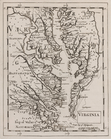
Chart of the entrance to
Chesapeake
Bay
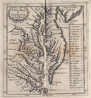
A new map of Virginia
note:
…
Va
. and
Md
.
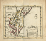
Virginia and Maryland
abstract:
…, in addition to
Chesapeake
Bay
Virginia.
note:
Covers
Chesapeake
Bay
Region.