Click to visit the main New York Public Library Homepage
The New York Public Library
Digital Collections
About Digital Collections
Browse
Search only public domain materials
Items
Collections
Divisions
Home
Search
Browse
About
Search only public domain materials
Items
Collections
Divisions
Digital Collections
Using Images
Using Data
Search
Filtered keyword search
Show filters
Hide filters
Show Only Public Domain
topic
Nautical charts
3
Coasts
1
Estate
1
Navigation
1
name
Bache, A. D. (Alexander Dallas), 1806-1867
2
Boutelle, C. O. (Charles Otis)
2
United States Coast Survey
2
Bauman, Wm. (William)
1
Berry, William, active 1669-1708
1
More
Less
collection
Maps of North America
4
I. N. Phelps Stokes Collection of American Historical Prints
1
Lawrence H. Slaughter Collection of English maps, charts, globes, books and atlases
1
place
New England
2
Africa
1
Atlantic Coast
1
Atlantic Coast (Canada)
1
Atlantic Coast (Mass.)
1
More
Less
genre
x
Maps
Bathymetric maps
3
Nautical charts
2
Prints
1
publisher
... Sold ... by Tho. Bowles, print and map-seller in St. Paul's-Churchyard
1
N.Y., P. & N.R.R
1
Published & sold by E. & G.W. Blunt, No. 179 Water Street, S.E. Corner of Burling Slip
1
R. Morden
1
The Survey
1
More
Less
division
Map Division
5
Wallach Division: Print Collection
1
type
cartographic
6
still image
1
Date Range
to
6 results found for:
x
Capé, Charles-François
Filtering on:
x
Genre
: Maps
Sort by:
Relevance
Title
Date created
Date digitized
Sequence
…. Scott's estate with
Cape
-
Charles
, the terminus
collection:
… with
Cape-Charles
, the terminus
Coast Chart no. 9, Boston Bay…
note:
… from
Cape
Ann to
Cape
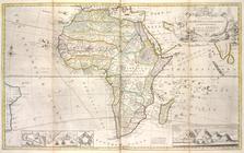
Map of Africa ...
note:
To the Right Honourable
Charles
Earl
Preliminary survey of Winyah Bay and
Cape
Roman
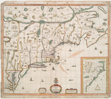
A map of ye English empire in…
note:
Print contains inset: [
Cape
Charles
m
… : from New York to
Cape
note:
… by
Charles
Copley, N.Y.