Click to visit the main New York Public Library Homepage
The New York Public Library
Digital Collections
About Digital Collections
Browse
Search only public domain materials
Items
Collections
Divisions
Home
Search
Browse
About
Search only public domain materials
Items
Collections
Divisions
Digital Collections
Using Images
Using Data
Search
Filtered keyword search
Show filters
Hide filters
Show Only Public Domain
topic
Real property
38
Cities & towns
11
Fire insurance
11
Railroads
11
Administrative and political divisions
10
More
Less
name
E.B. Hyde & Co
11
Sanborn Map Company
11
Ullitz, Hugo
11
E. Belcher Hyde Map Company
10
United States Coast Survey
10
More
Less
collection
Maps of North America
77
Atlases of New York City
29
Atlases of the United States
12
Bancker plans
9
Maps of New York City and State
7
More
Less
place
Louisiana
37
New York (State)
34
Brooklyn (New York, N.Y.)
14
New York
12
United States
11
More
Less
genre
x
Maps
Atlases
12
land surveys
12
Nautical charts
11
Surveys
10
More
Less
publisher
Sanborn Map Company
12
E. Belcher Hyde
10
publisher not identified
9
U.S. Coast Survey Office
6
U.S. Coast Survey
4
More
Less
division
Map Division
131
Manuscripts and Archives Division
10
George Arents Collection
2
Schomburg Manuscripts, Archives and Rare Books Division
2
General Research Division
1
More
Less
type
cartographic
149
text
6
still image
4
Date Range
to
150 results found for:
x
Louisiana Purchase Exposition (1904 : Saint Louis, Mo.)
Filtering on:
x
Genre
: Maps
Sort by:
Relevance
Title
Date created
Date digitized
Sequence
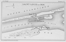
Saint
-
Louis
en 1854
Map of the city of St.
Louis
,
Mo
., 1861
m
Gilchrist's
purchase
Vernon Co.,
Mo
. …
Louisiana
m
Tottin and Crossfield's
purchase
m
Dr. Stuart's
purchase
m
I. Low's
purchase
m
Broadway - Charleton
purchase
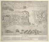
Saint
Augustine
Map of
Louisiana
…
Map of
Louisiana
abstract:
… depicting
Louisiana
justice
Map of
Louisiana
…
State of
Louisiana
…
Map of
Louisiana
…
Map of
Louisiana
…
Map of St. Joseph,
Mo
. and vicinity …
Map of St. Joseph,
Mo
. and vicinity …
The
Louisiana
State
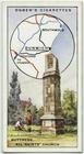
m
All
Saints
Church.
Saint
Lawrence County.
m
N. Depeyster's
purchase
in Duke Street
Tennessee Centennial
Exposition
abstract:
Bird's-eye view of the
Exposition
's grounds
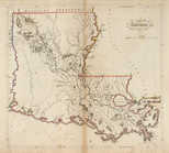
Map of the State of
Louisiana
…
m
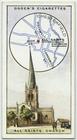
Buttress, All
Saints
Church.
Map of the city of
Saint
Paul …
m
Mr. Kortright's
purchase
from Vandewater
m
Mrs. Christie's
purchase
southeast side
… World's
Exposition
Preliminary chart of the Rigolets,
Louisiana
…
Map of
Louisiana
, Mississippi, and Arkansas.
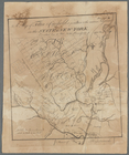
Map of the Parish of Winn,
Louisiana
…
Military map of part of
Louisiana
…
Map of the Parish of Carroll,
Louisiana
…
…,
Louisiana
…
Johnson's Arkansas, Mississippi, and
Louisiana
Louisiana
, as formerly claimed by France …
A new mapp of the Island of
SAINT
HELLENA
m
Henry White's
purchase
from the trustees
Map of Spanish
Louisiana
and the American
note:
… of
Louisiana
... (The Gentleman
…
Louisiana
…
Louisiana
Map of Spanish
Louisiana
and the American
note:
… of
Louisiana
... (The Gentleman
A map of Mexico,
Louisiana
, and the Missouri
Preliminary Chart of Atchafalaya Bay,
Louisiana
…
… of
Louisiana
Map of the South Western district
Louisiana
abstract:
Shows southwest
Louisiana
between the Sabine
Passe A Loutre, Mississippi Delta,
Louisiana
…
m
Post route map of the state of
Louisiana
…
Map of the city of St.
Louis
…
abstract:
… to Missouri and St.
Louis