Click to visit the main New York Public Library Homepage
The New York Public Library
Digital Collections
About Digital Collections
Browse
Search only public domain materials
Items
Collections
Divisions
Home
Search
Browse
About
Search only public domain materials
Items
Collections
Divisions
Digital Collections
Using Images
Using Data
Search
Filtered keyword search
Show filters
Hide filters
Show Only Public Domain
topic
Real property
1
name
Martin, D
2
Reid, John
2
Reid, John, publisher
2
Andrew B. Graham Co
1
Johnson, Martin G
1
More
Less
collection
Maps of North America
4
Lawrence H. Slaughter Collection of English maps, charts, globes, books and atlases
3
Maps of New York City and State
3
place
New York (State)
3
Bedford-Stuyvesant (New York, N.Y.)
1
Brooklyn (New York, N.Y.)
1
Delaware
1
Georgetown (Washington, D.C.) -- Maps -- Early works to 1800
1
More
Less
genre
x
Maps
Early maps
1
Early works to 1800
1
publisher
J. Reid
3
John Reid
1
Miller's Lith., 140 Pearl St
1
Publish'd by I. Reid,
1
Published by John Reid
1
More
Less
division
Map Division
10
type
cartographic
10
Date Range
to
10 results found for:
x
Reid, John
Filtering on:
x
Genre
: Maps
Sort by:
Relevance
Title
Date created
Date digitized
Sequence
The Province of Maine, from t…
note:
…. : J.
Reid
, 1796.
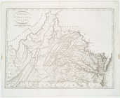
The State of Virginia from th…
The states of Maryland and De…
note:
Appears in
John
Reid
's American atlas.
Plan of the city of Washingto…
The State of Pennsylvania fro…
The State of New Jersey, comp…
note:
… :
John
Reid
, [1796]. [No
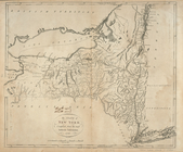
The state of New York, compil…
note:
… atlas. New-York :
John
Reid
, [1796]. [No.] 10.
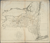
The state of New York, compil…
note:
… atlas. New-York :
John
Reid
, [1796]. [No.] 10.
Map of the "Hunter Fly Farm" …
abstract:
Shows lots for area between
Reid
and Hopkinson
m
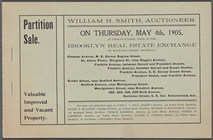
Partition Sale
note:
… & Degraw St; St.
Johns