Click to visit the main New York Public Library Homepage
The New York Public Library
Digital Collections
About Digital Collections
Browse
Search only public domain materials
Items
Collections
Divisions
Home
Search
Browse
About
Search only public domain materials
Items
Collections
Divisions
Digital Collections
Using Images
Using Data
Search
Filtered keyword search
Show filters
Hide filters
Show Only Public Domain
topic
Nautical charts
6
Harbors
2
Coasts
1
Inlets
1
name
Bache, A. D. (Alexander Dallas), 1806-1867
6
United States Coast Survey
6
Bromley, George Washington
4
Bromley, Walter Scott
4
G.W. Bromley & Co
4
More
Less
collection
Maps of North America
6
Atlases of New York City
4
place
Staten Island (New York, N.Y.)
4
Atlantic Coast (Mass.)
2
Little Egg Harbor (N.J. : Township)
2
Massachusetts
2
New Bedford (Mass.)
2
More
Less
genre
x
Maps
Nautical charts
4
Bathymetric maps
1
publisher
G.W. Bromley & Co
4
United States Coast Survey
3
The Survey
2
U.S. Coast Survey Office
1
division
Map Division
10
type
cartographic
10
still image
1
Date Range
to
10 results found for:
x
Sand, George
Filtering on:
x
Genre
: Maps
Sort by:
Relevance
Title
Date created
Date digitized
Sequence
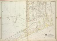
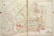
… by Richmond Ave, Sea Ave (
Sand
…, Richmond Ave,
Sand
Lane]
Preliminary chart of Ship and
Sand
Shoal
The harbor of New Bedford
note:
…. on a mid line between
Sand
The harbor of New Bedford
note:
…. on a mid line between
Sand
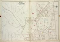
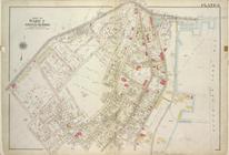
… (Richmond RD),
Sands
St
… (Richmond RD),
Sands
St
Little Egg Harbor
note:
… & B.F.
Sands
U.S.N. & C
Little Egg Harbor
note:
… & B.F.
Sands
U.S.N. & C
Preliminary chart of Tomales …
note:
…. Alden and B.F.
Sands