Click to visit the main New York Public Library Homepage
The New York Public Library
Digital Collections
About Digital Collections
Browse
Search only public domain materials
Items
Collections
Divisions
Home
Search
Browse
About
Search only public domain materials
Items
Collections
Divisions
Digital Collections
Using Images
Using Data
Search
Filtered keyword search
Show filters
Hide filters
Show Only Public Domain
topic
Atlases
5
Historical geography
5
Maps in education
5
History
4
Boundaries
3
More
Less
name
Faden, William, 1749-1836
12
Symons, T. W. (Thomas William), 1849-1920
5
Downing, Alfred
4
Foot, T. (Thomas)
4
Jefferys & Faden (London, England)
3
More
Less
collection
Maps of North America
20
Lawrence H. Slaughter Collection of English maps, charts, globes, books and atlases
9
Maps of New York City and State
3
I. N. Phelps Stokes Collection of American Historical Prints
2
New York City directories
1
More
Less
place
England
6
Great Britain
6
New York (State)
4
Northwest, Pacific
4
United States
4
More
Less
genre
x
Maps
Nautical charts
2
Prints
2
Books
1
Cadastral maps
1
More
Less
publisher
Published by Wm. Faden, geographer to His Majesty, and His R.H. the Prince of Wales
5
Office of the Chief of Engineers, U.S. Army
3
publisher not identified
3
Printed for R. and J. Dodsley..
2
Publish[e]d ... by Jefferys & Faden, corner of St. Martins Lane, Charing Cross
2
More
Less
division
Map Division
32
Wallach Division: Print Collection
2
Rare Book Division
1
Wallach Division: Art & Architecture Collection
1
type
cartographic
36
still image
2
text
1
Date Range
to
36 results found for:
x
Thomas, William C
Filtering on:
x
Genre
: Maps
Sort by:
Relevance
Title
Date created
Date digitized
Sequence
Map of the Department of the …
parent:
63024260-9ef3-0134-21e6-00505686a51
c
Geometrical plan of the garde…
parent:
02ece8d0-
c
6bf-012f-cce4-58d385a7bc34
Map of the Department of the …
parent:
f6389e40-9ef4-0134-6b2b-00505686a51
c
A mapp of ye improved part of…
parent:
2
c
631510-
c
5ed-012f-5
c
33-58d385a7bc34
A plan of the town of Boston:…
parent:
de88d310-7
c
50-0134-1349-00505686a51
c
m
Map of the Department of the …
parent:
e0aa70a0-9eee-0134-886e-00505686a51
c
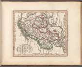
Hind, Hindoostan, or India
parent:
368fb9b0-
c
5d4-012f-90b6-58d385a7bc34
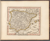
Hispania Vetus
parent:
52ef9f40-a4f2-0137-63
c
0-43363b712681
A prospective plan on the bat…
parent:
39bb8900-
c
5ed-012f-2af7-58d385a7bc34
Scandinavia comprehending Swe…
parent:
1839fb10-a7eb-0137-
c
75
c
-08fe7cffbe37
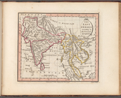
The East Indies according to …
parent:
368fb9b0-
c
5d4-012f-90b6-58d385a7bc34
Orbis veteribus notus
parent:
368fb9b0-
c
5d4-012f-90b6-58d385a7bc34
…, Cold Springs, &
c
parent:
bd064270-0bec-0134-d164-00505686a51
c
…, or Netherlands &
c
.
parent:
f7e1d310-
c
5d3-012f-b5f0-58d385a7bc34
A Map of the British and Fren…
parent:
f67936d0-
c
52a-012f-279
c
-3
c
075448cc4b
Map of Teller Reindeer Statio…
parent:
754110
c
0-ed99-0135-2a28-39b95def7574
This plan of the city of Balt…
parent:
4ae5a4
c
0-
c
52b-012f-967a-3
c
075448cc4b
m
New York City directory, 1791
parent:
f554e950-81ae-0134-b4cf-00505686a51
c
Plan of the city of New York …
parent:
ecdff270-
c
5aa-012f-d891-58d385a7bc34
m
Plan of the city of New York …
parent:
ed619490-
c
5aa-012f-7ed8-58d385a7bc34
Plan of the city of New York …
parent:
8
c
574e20-
c
5d5-012f-a732-58d385a7bc34
Map of the United States and …
parent:
8f629360-5104-0134-1dac-00505686a51
c
A map of the state of New Jer…
parent:
5961
c
110-
c
52b-012f-b92b-3
c
075448cc4b
Map of the boundary lines bet…
parent:
a9f066a0-54
c
7-0133-8d30-00505686a51
c
A plan of the attack of Fort …
parent:
4162e680-
c
52b-012f-
c
2dc-3
c
075448cc4b
Map of the Department of the …
parent:
c
6090a40-58fc-0134-cc5a-00505686a51
c
Topographical map of the Dist…
parent:
91a438
c
0-
c
52b-012f-bc7b-3
c
075448cc4b
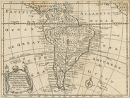
An accurate map of South Amer…
parent:
6ad2def0-
c
5d4-012f-a7b9-58d385a7bc34
Map showing different routes …
parent:
7e65d320-7
c
54-0135-14
c
5-08b3e6a1db59
General map to accompany the …
parent:
83627f90-b5
c
4-0135-18cd-5141e3e2cd49
Plan of the siege of Charlest…
parent:
a75b14e0-538d-0135-cc22-04b5891249
c
9
Chart of Narraganset Bay : su…
parent:
1f03cb30-df35-0134-e7
c
8-611a4a8adb80
A plan of the attack of Fort …
parent:
d046e100-4ee7-0135-e757-0f6811
c
1319a
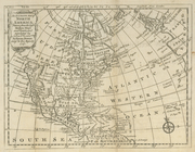
An accurate map of North Amer…
parent:
6a5739
c
0-
c
5d4-012f-7f0b-58d385a7bc34
Map of North Carolina
parent:
ebc65960-3fd4-0135-6
c
61-536e1487789d
Preliminary chart of Plymouth…
parent:
13180400-6bc6-0134-d489-00505686a51
c
End of results
|
Top