Click to visit the main New York Public Library Homepage
The New York Public Library
Digital Collections
About Digital Collections
Browse
Search only public domain materials
Items
Collections
Divisions
Home
Search
Browse
About
Search only public domain materials
Items
Collections
Divisions
Digital Collections
Using Images
Using Data
Search
Filtered keyword search
Show filters
Hide filters
Show Only Public Domain
topic
Railroads
37
Administrative and political divisions
26
Real property
18
Canals
17
Cities & towns
12
More
Less
name
Sanborn Map Company
12
Faden, William, 1749-1836
5
Burr, David H., 1803-1875
4
E. Belcher Hyde Map Company
4
E.B. Hyde & Co
4
More
Less
collection
Maps of North America
45
Maps of New York City and State
30
Atlases of New York City
20
Lawrence H. Slaughter Collection of English maps, charts, globes, books and atlases
7
Atlases of the United States
6
More
Less
place
New York (State)
58
Vermont
51
Connecticut
27
Massachusetts
26
New England
19
More
Less
genre
x
Maps
Atlases
5
Early maps
3
Early works to 1800
2
Cadastral maps
1
More
Less
publisher
Sanborn Map Company
12
publisher not identified
12
E. Belcher Hyde
6
New York State Board of Railroad Commissioners?
3
Publish'd by Laurie & Whittle, 53 Fleet Street
3
More
Less
division
Map Division
114
Manuscripts and Archives Division
1
Wallach Division: Picture Collection
1
type
cartographic
115
still image
3
Date Range
to
116 results found for:
x
Vermont
Filtering on:
x
Genre
: Maps
Sort by:
Relevance
Title
Date created
Date digitized
Sequence
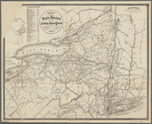
Rand, McNally & Co.'s
Vermont
Map of the state of
Vermont
…
note:
Appears in: Walton's
Vermont
register, business
Vermont
, from actual survey …
note:
Includes tables: Census of
Vermont
, A.D
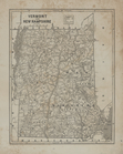
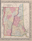
Johnson's
Vermont
and New Hampshire
… Hampshire &
Vermont
Map of the state of
Vermont
…
abstract:
… of
Vermont
/ compiled
Map of the
Vermont
Central Rail Road and its
note:
Covers
Vermont
and adjacent states.
New Hampshire &
Vermont
m
Part of
Vermont
note:
Showing counties in
Vermont
.
Brattleboro and vicinity : co…
abstract:
Subject: Map of Brattleboro,
Vermont
New Hampshire &
Vermont
note:
… and
Vermont
, Massachusetts
Position of the detachment un…
abstract:
… and
Vermont
.
Plan of the action at Huberto…
collection:
Vermont
A plan of the town of Pittsfo…
collection:
Vermont
Vermont
, from actual survey
… d'etat de
Vermont
abstract:
… and
Vermont
. Relief shown
m
A correct map of the state of
Vermont
, from
Map of the meetings constitut…
Map of the rail roads of the …
note:
… all of
Vermont
Map of Bennington County,
Vermont
…
Vermont
and New Hampshire.
… d'etat de
Vermont
.
note:
Covers eastern New York State and
Vermont
.
… by Highland Blvd.,
Vermont
St
Map of the meetings constitut…
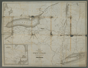
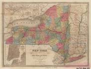
Map of New York
note:
Covers most of
Vermont
and Connecticut
A new and accurate map of the…
Johnson's
Vermont
, New Hampshire
A map of the county between C…
collection:
… and
Vermont
, between Crown
m
Map of the rail-roads of the …
note:
Covers parts of adjacent states:
Vermont
Map of the state of New York:…
abstract:
Covers all of
Vermont
and Connecticut
Plan of the action of Huberto…
collection:
Vermont
Map of the rail-roads of the …
G. Woolworth Colton's series …
collection:
Maine, New Hampshire,
Vermont
Map of the rail-roads of the …
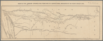
Route of the Lebanon Springs …
note:
… of Massachusetts,
Vermont
Map of the state of New York …
note:
Also cover
Vermont
, Connecticut, and part of New
Map of the rail roads of the …
abstract:
… all of
Vermont
Map of the rail roads of the …
note:
… all of
Vermont
Map of Providence and Worcest…
note:
…,
Vermont
, New Hampshire
Map of Massachusetts,
Vermont
, New
NE sheet of map of North Amer…
Windham County, Vt.: To accom…
collection:
Vermont
Battle of Hubbardton
topic:
Campaigns & battles --
Vermont
-- 1777
New Hampshire and
Vermont
.
Map of Providence and Worcest…
note:
…,
Vermont
, New Hampshire
m
Post route map of the State o…
note:
… and
Vermont
].
… Parkway,
Vermont
Ave.]
….,
vermont
]
Map of New England, with adja…
… of New York,
Vermont
, New