Click to visit the main New York Public Library Homepage
The New York Public Library
Digital Collections
About Digital Collections
Browse
Search only public domain materials
Items
Collections
Divisions
Home
Search
Browse
About
Search only public domain materials
Items
Collections
Divisions
Digital Collections
Using Images
Using Data
Search
Filtered keyword search
Show filters
Hide filters
Show Only Public Domain
topic
Geography
1
name
x
Moll, Herman, -1732
Bowles, Thomas, 1694-1773
1
Childe, Timothy
1
Falconer, Robert, active 1700
1
Luyts, Jan, 1655-1721
1
collection
Lawrence H. Slaughter Collection of English maps, charts, globes, books and atlases
2
genre
Maps
2
publisher
... Sold ... by Tho. Bowles, print and map-seller in St. Paul's-Churchyard
1
Printed for Timothy Childe at the White Hart at the West-end of St. Paul's Church-yard
1
division
Map Division
2
type
x
cartographic
Date Range
to
2 results found for:
x
Sweden
Filtering on:
x
Name
: Moll, Herman, -1732
x
Type
: cartographic
Sort by:
Relevance
Title
Date created
Date digitized
Sequence
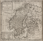
Sweden
, and Norway.
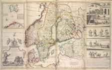
A new map of Denmark and
Sweden
. ...