Click to visit the main New York Public Library Homepage
The New York Public Library
Digital Collections
About Digital Collections
Browse
Search only public domain materials
Items
Collections
Divisions
Home
Search
Browse
About
Search only public domain materials
Items
Collections
Divisions
Digital Collections
Using Images
Using Data
Search
Filtered keyword search
Show filters
Hide filters
Show Only Public Domain
topic
Real property
102
Administrative and political divisions
1
Historical geography
1
Landowners
1
name
G.M. Hopkins & Co
101
Dripps, M. (Matthew)
1
Harrison, J. F
1
Magrane, T
1
collection
Atlases of New York City
101
Maps of New York City and State
1
place
x
Brooklyn (New York, N.Y.)
New York
102
New York (State)
102
Manhattan (New York, N.Y.)
1
New York (N.Y.)
1
More
Less
genre
Maps
102
publisher
G.M. Hopkins & Co
101
M. Dripps
1
division
Map Division
102
type
x
cartographic
Date Range
to
102 results found for:
x
M. C
Filtering on:
x
Place
: Brooklyn (New York, N.Y.)
x
Type
: cartographic
Sort by:
Relevance
Title
Date created
Date digitized
Sequence
Topographical map of New York…
parent:
6cea9e80-
c
5aa-012f-63d6-58d385a7bc34
Map bound by Starr St., Wycko…
parent:
b2db5690-
c
5fa-012f-8327-58d385a7bc34
Map bound by Roges Ave., City…
parent:
ab84bf80-
c
5fa-012f-4130-58d385a7bc34
Map bound by Greenwood Cemete…
parent:
ba367b60-
c
5fa-012f-4165-58d385a7bc34
Map bounded by Lafayette Ave.…
parent:
a83eb0d0-
c
5fa-012f-ee70-58d385a7bc34
Map bound by Butler St., Four…
parent:
c
0ce3da0-
c
5fa-012f-96b7-58d385a7bc34
Map bound by Grand St., Seven…
parent:
c
881b830-
c
5fa-012f-a0e1-58d385a7bc34
Map bound by Fifth Ave., Fift…
parent:
b6acdd40-
c
5fa-012f-955b-58d385a7bc34
Map bound by Manhattan Ave., …
parent:
c
4f05430-
c
5fa-012f-f2df-58d385a7bc34
Map bound by Division Pl., Ne…
parent:
af7baa20-
c
5fa-012f-367e-58d385a7bc34
Map bound by Poplar St., Sand…
parent:
bd62d650-
c
5fa-012f-04cb-58d385a7bc34
Detailed Estate and Old Farm …
parent:
c
43
c
2db0-
c
5fa-012f-0548-58d385a7bc34
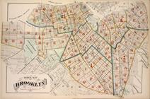
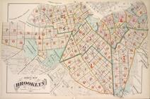
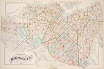
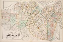
Index Map of Brooklyn
parent:
b5a78460-
c
5fa-012f-3e07-58d385a7bc34
Index Map of Brooklyn
parent:
bc517d70-
c
5fa-012f-cd65-58d385a7bc34
Index Map of Brooklyn
parent:
c
3f49ad0-
c
5fa-012f-4124-58d385a7bc34
Index Map of Brooklyn
parent:
a7574430-
c
5fa-012f-4285-58d385a7bc34
Index Map of Brooklyn
parent:
ae686670-
c
5fa-012f-d1
c
1-58d385a7bc34
Map bound by Stanhope St., Wy…
parent:
b38abf10-
c
5fa-012f-
c
733-58d385a7bc34
Map bound by Fifth St., Sixth…
parent:
b70fd2d0-
c
5fa-012f-e297-58d385a7bc34
Map bound by First St., Ninth…
parent:
b75d8d70-
c
5fa-012f-
c
7dd-58d385a7bc34
Map bound by Tenth St., Ninth…
parent:
b7bc01
c
0-
c
5fa-012f-5a0f-58d385a7bc34
Map bound by Atlantic Ave., C…
parent:
bf165ef0-
c
5fa-012f-1b1
c
-58d385a7bc34
Map bound by Harrison St., Co…
parent:
c
06e3520-
c
5fa-012f-471e-58d385a7bc34
Map bound by Partition St., O…
parent:
c
285ffc0-
c
5fa-012f-a933-58d385a7bc34
Map bound by Henry St. Slip, …
parent:
c
34062a0-
c
5fa-012f-9da2-58d385a7bc34
Map bounded by Lafayette Ave.…
parent:
a7a518d0-
c
5fa-012f-d063-58d385a7bc34
Map bounded by Lafayette Ave.…
parent:
a7f95d30-
c
5fa-012f-8e73-58d385a7bc34
Map bounded by Putnam Ave., S…
parent:
a8e3fa40-
c
5fa-012f-410a-58d385a7bc34
Map bounded by Madison St., R…
parent:
a9452410-
c
5fa-012f-
c
53a-58d385a7bc34
Map bounded by Madison St., B…
parent:
a988cad0-
c
5fa-012f-7245-58d385a7bc34
Map bound by Atlantic Ave., N…
parent:
a9dcd9
c
0-
c
5fa-012f-bf0a-58d385a7bc34
Map bound by Herkimer St., Tr…
parent:
aa29daa0-
c
5fa-012f-7828-58d385a7bc34
Map bound by Meeker Ave., New…
parent:
af19d1
c
0-
c
5fa-012f-
c
758-58d385a7bc34
Map bound by Dean St., Pacifi…
parent:
ac6
c
7590-
c
5fa-012f-
c
19
c
-58d385a7bc34
Map bound by Douglass St., Bu…
parent:
acc88140-
c
5fa-012f-b581-58d385a7bc34
Map bound by Atlantic Ave., H…
parent:
ad11e0f0-
c
5fa-012f-2450-58d385a7bc34
Map bound by Prospect Pl., Ho…
parent:
ad74ad80-
c
5fa-012f-96be-58d385a7bc34
Map bound by La Fayette Ave.,…
parent:
b33b4e50-
c
5fa-012f-5685-58d385a7bc34
Map bound by Central Ave., Sc…
parent:
b3ef2090-
c
5fa-012f-e112-58d385a7bc34
Map bound by Magnolia St., Ci…
parent:
b45083
c
0-
c
5fa-012f-2ed4-58d385a7bc34
Map bound by City Line, Cemet…
parent:
b4978440-
c
5fa-012f-4316-58d385a7bc34
Map bound by Central Ave., Ce…
parent:
b4fbdf80-
c
5fa-012f-d744-58d385a7bc34
Map bound by Atlantic Ave., F…
parent:
b5fdd430-
c
5fa-012f-bd58-58d385a7bc34
Map bound by St. Johns Place,…
parent:
b65e82a0-
c
5fa-012f-fd43-58d385a7bc34
Map bound by Thirteenth St., …
parent:
b80bd4e0-
c
5fa-012f-513f-58d385a7bc34
Map bound by Prospect Ave., N…
parent:
b87316f0-
c
5fa-012f-a23
c
-58d385a7bc34
Map bound by Ninth Ave., Pros…
parent:
b8dbb6
c
0-
c
5fa-012f-8bcc-58d385a7bc34
Map bound by Twentieth St., F…
parent:
b92d9660-
c
5fa-012f-88fc-58d385a7bc34
Map bound by Twenty-Eighth St…
parent:
b987cbf0-
c
5fa-012f-dd3e-58d385a7bc34
Map bound by Thirty-Sixth, Fi…
parent:
b9d3ca60-
c
5fa-012f-4a70-58d385a7bc34