Click to visit the main New York Public Library Homepage
The New York Public Library
Digital Collections
About Digital Collections
Browse
Search only public domain materials
Items
Collections
Divisions
Home
Search
Browse
About
Search only public domain materials
Items
Collections
Divisions
Digital Collections
Using Images
Using Data
Search
Filtered keyword search
Show filters
Hide filters
Show Only Public Domain
topic
Administrative and political divisions
2
name
Breese, Samuel, 1802-1873
2
Burr, David H., 1803-1875
2
J.H. Colton & Co
2
Morse, Sidney E. (Sidney Edwards), 1794-1871
2
S. Stiles & Co
2
More
Less
collection
Maps of New York City and State
4
Atlases of the United States
2
place
x
Manhattan (New York, N.Y.) -- Maps
New York (N.Y.) -- Maps
5
New York (N.Y.) -- Administrative and political divisions -- Maps
4
Brooklyn (New York, N.Y.) -- Maps
3
Brooklyn (New York, N.Y.)
2
More
Less
genre
Maps
6
publisher
S. E. Morse & co.,
2
Published by H.S. Tanner map selr., 237 Broadway,
1
Published by J.H. Colton & Co,
1
Published by J.H. Colton & Co.,
1
Published by Tanner & Disturnell, No. 124 Broadway,
1
division
Map Division
6
type
cartographic
6
Date Range
to
6 results found for:
x
act up
Filtering on:
x
Place
: Manhattan (New York, N.Y.) -- Maps
Sort by:
Relevance
Title
Date created
Date digitized
Sequence
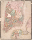
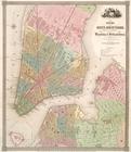
City of New-York
note:
…"Entered according to
act
of Congress
City of New-York
note:
Covers Manhattan
up
to 26th St. on the west
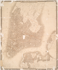
New York and vicinity.
note:
…"Entered according to
Act
of Congress
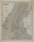
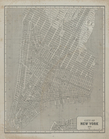
New map of the city of New Yo…
note:
…"Entered according to
act
of Congress
New map of the city of New Yo…
note:
…"Entered according to
act
of Congress
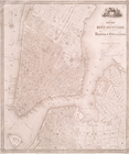
City of New York, 1843.
note:
…"Entered according to
Act
of Congress