Click to visit the main New York Public Library Homepage
The New York Public Library
Digital Collections
About Digital Collections
Browse
Search only public domain materials
Items
Collections
Divisions
Home
Search
Browse
About
Search only public domain materials
Items
Collections
Divisions
Digital Collections
Using Images
Using Data
Search
Filtered keyword search
Show filters
Hide filters
Show Only Public Domain
topic
Atlases
3
Atlases, British
3
Nautical charts
3
Coasts
1
World maps
1
name
Seller, John, active 1658-1698
4
Visscher, Nicolaes, 1618-1679
3
Wit, Frederik de
3
Blome, Richard, -1705
1
Clerk, James, active 1680-1695
1
More
Less
collection
Lawrence H. Slaughter Collection of English maps, charts, globes, books and atlases
5
place
x
Maps
Atlantic Coast (Middle Atlantic States)
1
Atlantic Coast (New England)
1
Atlantic Coast (North America)
1
Atlantic Ocean
1
More
Less
genre
Maps
5
publisher
And are to be sold at his shopps in Wapping at the Hermitage and in Exchange-Alley near the Royall-Exchange ..
3
Printed by John Darby for the author, and are to be sold at his shop at the Hermitage in Wapping,
1
by Ier. Seller and Ch. Price, hydrographers to the Queen, at the Hermitage Staires and at their Shopp next the Fleece Taverne in Cornhill
1
division
Map Division
5
type
cartographic
5
Date Range
to
5 results found for:
x
Hermitages
Filtering on:
x
Place
: Maps
Sort by:
Relevance
Title
Date created
Date digitized
Sequence
A chart of the West Indies fr…
note:
…, at the
Hermitage
Stairs in Wapping
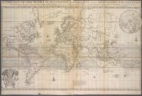
A new map of the world accord…
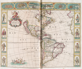
Nova totivs Americæ descripti…
A general chart of the West I…
A chart of the sea coasts of …