Click to visit the main New York Public Library Homepage
The New York Public Library
Digital Collections
About Digital Collections
Browse
Search only public domain materials
Items
Collections
Divisions
Home
Search
Browse
About
Search only public domain materials
Items
Collections
Divisions
Digital Collections
Using Images
Using Data
Search
Filtered keyword search
Show filters
Hide filters
Show Only Public Domain
name
Fry, Joshua, approximately 1700-1754
4
Jefferson, Peter, 1708-1757
4
Jefferys, Thomas, -1771
4
Sayer, Robert, 1725-1794
2
Jefferson, Thomas, 1743-1826
1
More
Less
collection
Lawrence H. Slaughter Collection of English maps, charts, globes, books and atlases
5
place
x
Middle Atlantic States -- Maps -- Early works to 1800
Maryland -- Maps -- Early works to 1800
4
Virginia -- Maps -- Early works to 1800
4
Delaware
1
Maryland
1
More
Less
genre
Maps
5
publisher
Printed for Robt. Sayer at No. 53 in Fleet Street, & Thos. Jefferys at the corner of St. Martins Lane, Charing Cross,
2
... Published according to Act of Parliament by Thos. Jefferys, geographer to His Royal Highness the Prince of Wales at the corner of St. Martins Lane, Charing Cross,
1
Published ... by Laurie & Whittle, No. 53, Fleet Street,
1
division
Map Division
5
type
cartographic
5
Date Range
to
5 results found for:
x
Jefferson, Thomas
Filtering on:
x
Place
: Middle Atlantic States -- Maps -- Early works to 1800
Sort by:
Relevance
Title
Date created
Date digitized
Sequence
A map of the country between …
note:
… and
Jefferson
's Map of Virginia
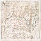
A map of the most inhabited p…
note:
Described in: Fry &
Jefferson
map of Virginia
m
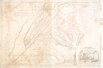
A map of the most inhabited p…
note:
Described in: Fry &
Jefferson
map of Virginia
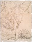
A map of the most inhabited p…
note:
Described in: Fry &
Jefferson
map of Virginia
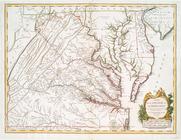
A map of the most inhabited p…
note:
Described in: Fry &
Jefferson
map of Virginia