Click to visit the main New York Public Library Homepage
The New York Public Library
Digital Collections
About Digital Collections
Browse
Search only public domain materials
Items
Collections
Divisions
Home
Search
Browse
About
Search only public domain materials
Items
Collections
Divisions
Digital Collections
Using Images
Using Data
Search
Filtered keyword search
Show filters
Hide filters
Show Only Public Domain
topic
x
Administrative and political divisions
Roads
5
Steamboat lines
4
Ferries
3
Bicycle trails
2
More
Less
name
Geo. H. Walker & Co
13
Geo. H. Walker & Co
1
Geological Survey (U.S.)
1
Thompson, John Clifford, 1828 or 1829-1894
1
U.S. Coast and Geodetic Survey
1
More
Less
collection
Maps of North America
12
Maps of New York City and State
2
place
Massachusetts
7
Boston
5
Boston (Mass.)
5
Boston Metropolitan Area (Mass.)
4
Boston Harbor (Mass.)
2
More
Less
genre
Maps
14
Road maps
3
Topographic maps
2
publisher
x
Geo. H. Walker & Co
Geo. H. Walker & Co.'s Lith
1
division
Map Division
14
type
cartographic
14
Date Range
to
14 results found for:
x
Walker
Filtering on:
x
Publisher
: Geo. H. Walker & Co.
x
Topic
: Administrative and political divisions
Sort by:
Relevance
Title
Date created
Date digitized
Sequence
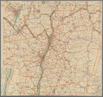
Road map of the Albany-Troy d…
note:
Copyright 1897 by Geo. H.
Walker
& Co
Rhode Island
note:
…"Copyright 1898 by Geo. H.
Walker
& Co."…
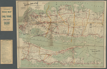
Map of Long Island
note:
…"Copyright 1897 by Geo. H.
Walker
& Co
City of Malden: [Massachusett…
note:
Probably from: O.W.
Walker
's Atlas
Map of Boston and vicinity
note:
Geo. H.
Walker
& Co., engravers, Boston.
Map of Connecticut
Map of Berkshire County
Boston and surroundings
Map of Cambridge and Somervil…
Railroad and post office map …
Indexed map of Boston
Boston and surroundings
m
Boston and surroundings
Topographical map of the stat…
End of results
|
Top