Click to visit the main New York Public Library Homepage
The New York Public Library
Digital Collections
About Digital Collections
Browse
Search only public domain materials
Items
Collections
Divisions
Home
Search
Browse
About
Search only public domain materials
Items
Collections
Divisions
Digital Collections
Using Images
Using Data
Search
Filtered keyword search
Show filters
Hide filters
Show Only Public Domain
topic
x
City planning
Streets
4
Administrative and political divisions
2
Real property
2
Fires
1
More
Less
name
Haffen, Louis F., 1854-1935
2
Risse, Louis A
2
Welcke, Robert A
2
Davis, Thomas W. (Surveyor)
1
Heliotype Printing Co
1
More
Less
collection
Maps of New York City and State
3
Maps of North America
3
place
Manhattan (New York, N.Y.)
3
Massachusetts
3
New York
3
New York (N.Y.)
3
New York (State)
3
More
Less
genre
Maps
6
Cadastral maps
2
publisher
x
publisher not identified
Robert A. Welcke, Photo-Lith
1
division
Map Division
6
type
cartographic
6
Date Range
to
6 results found for:
x
maps
Filtering on:
x
Publisher
: publisher not identified
x
Topic
: City planning
Sort by:
Relevance
Title
Date created
Date digitized
Sequence
Plan of Public Garden: showin…
note:
Mapping
the Nation (NEH grant, 2015-2018)…
Plan of burnt district (by fi…
note:
Mapping
the Nation (NEH grant, 2015-2018)…
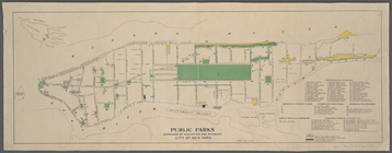
Public parks boroughs of Manh…
note:
Inset
map
of Staten Island and vicinity.
Map
of the city of Worcester showing
note:
Mapping
the Nation (NEH grant, 2015-2018)…
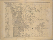
Map
of the 23rd and 24th wards of the City
collection:
Map
of the 23rd and 24th wards
Map
of the 23rd and 24th wards of the City
collection:
Map
of the 23rd and 24th wards