Click to visit the main New York Public Library Homepage
The New York Public Library
Digital Collections
About Digital Collections
Browse
Search only public domain materials
Items
Collections
Divisions
Home
Search
Browse
About
Search only public domain materials
Items
Collections
Divisions
Digital Collections
Using Images
Using Data
Search
Filtered keyword search
Show filters
Hide filters
Show Only Public Domain
topic
Real property
18
History
17
Landowners
15
Railroads
8
Administrative and political divisions
7
More
Less
name
Siege of Yorktown (Virginia : 1781)
3
American Revolution (1775-1783)
2
Bache, Hartman, 1797-1872
2
Bauman, Sebastian
2
Bronson, Isaac, 1760-1838
2
More
Less
collection
Maps of North America
86
Maps of New York City and State
6
place
Pennsylvania
15
Virginia
13
South Carolina
9
Charleston
6
North Carolina
6
More
Less
genre
Maps
92
Cadastral maps
14
Nautical charts
5
Geological maps
4
Bathymetric maps
3
More
Less
publisher
x
publisher not identified
D. McLellan, lithographer
1
division
Map Division
92
type
x
cartographic
still image
2
text
2
Date Range
to
92 results found for:
x
17
Filtering on:
x
Publisher
: publisher not identified
x
Type
: cartographic
Sort by:
Relevance
Title
Date created
Date digitized
Sequence
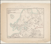
Railroad map of New England
parent:
1a1245f0-0a60-0134-
17
e8-00505686a51c
City of New Haven
Map of the city of New Haven
Yosemite Valley : [Calif.]
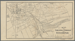
Map of Saratoga Springs and E…
A map of the colonies of Conn…
Mail and passenger route from…
Plan de la Baye de Pensacola …
Charleston : and adjacent cou…
Map of Brooklyn during the Ba…
A map of the countrey of the …
m
Map of the Grand Rapids and I…
m
Lands in the State of North C…
note:
… also Map Div.
17
-5015
m
Lands in the State of North C…
note:
… also Map Div.
17
-5017 c
A bird's-eye view of the city…
Map of Pennsylvania showing p…
A sketch of the Cherakee boun…
The Delaware River from the F…
parent:
00332520-f140-0134-
17
b5-7f8d38f81c1b
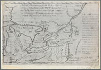
Plan of the seat of war : [Vi…
Map of part of Fauquier Count…
Map of the city of Newport an…
Map of routes & distances to …
A map of part of the Province…
Approach of the Union Armies …
Map of part of Washington and…
Map of Great Barn Island, New…
Half of an unidentified map s…
Map of the oil region, Venang…
Map of Chattanooga, Tenn.
A plan of Charles Town, the c…
Octagonal map of the environs…
Plat of the private claims at…
Map of Castle Hill & Price's …
Northwestern section of a map…
parent:
17
e12c30-ee47-0135-9f3f-13899789ad41
Plan of the entrance into Cap…
Map of the Clinton County Coa…
Map of the state of Missouri …
Map of the city of Washington…
parent:
f64b3c80-f13a-0134-9450-
17
ea6a972d35
Whitesboro, Brown Co., W.T.
Map of the city of Washington…
A plan of the town of Pittsfo…
Map of the tertiary of Essex …
Sketch showing route of gener…
Map of lands belonging to Jam…
Map of the city of Erie : sho…
A map of the Virginia Central…
Rhode - Island, 2e feuille
A plan of Charles town
South-Carolina and parts adja…
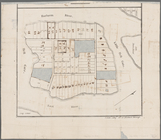
Plan of York Town in Virginia…