Click to visit the main New York Public Library Homepage
The New York Public Library
Digital Collections
About Digital Collections
Browse
Search only public domain materials
Items
Collections
Divisions
Home
Search
Browse
About
Search only public domain materials
Items
Collections
Divisions
Digital Collections
Using Images
Using Data
Search
Filtered keyword search
Show filters
Hide filters
Show Only Public Domain
topic
Geology
6
Anthracite coal mines and mining
5
Anthracite coal
2
Anthracite coal industry
2
Coal mines and mining
2
More
Less
name
Ashburner, Charles A. (Charles Albert), 1854-1889
11
Hart, Lane S
11
Lesley, J. P. (J. Peter), 1819-1903
10
Geological Survey of Pennsylvania
9
Julius Bien & Co
8
More
Less
collection
Maps of North America
21
Lawrence H. Slaughter Collection of English maps, charts, globes, books and atlases
2
Atlases of the United States
1
Henry David Thoreau collection
1
Maps of New York City and State
1
place
Pennsylvania
13
Schuylkill County
6
Carbon County
5
Schuylkill County (Pa.)
4
United States
4
More
Less
genre
Maps
25
Geological cross-sections
6
Topographic maps
4
Charts
3
Diagrams
3
More
Less
publisher
Geological Survey of Pennsylvania
9
M. A. Lotter
3
Board of Commissioners for the Second Geological Survey
2
U.S. Geological Survey
2
J.K. Wiggin
1
More
Less
division
Map Division
25
Berg Collection
1
type
x
cartographic
text
1
Date Range
to
26 results found for:
x
Albert, J
Filtering on:
x
Rights
: Public Domain
x
Type
: cartographic
Sort by:
Relevance
Title
Date created
Date digitized
Sequence
m
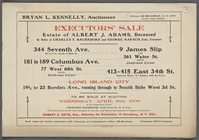
Executor's Sale Estate of
Albert
J
. Adams
m
Walden Pond. A reduced plan. …
note:
Note on verso "E.
J
. Weir from Sophia E
Map of a reconnoissance betwe…
note:
… of Col.
J.J
. Abert, chief
A map of the provinces of New…
note:
Described in Babinski's Notes on C.
J
General-Karte der Vereinigten…
note:
… Karten von
J
. Calvin
A map of the provinces of New…
note:
Described in Babinski's Notes on C.
J
General map of the anthracite…
note:
… ;
J
.P. Lesley, state
General map of the anthracite…
note:
…,
J
.P. Lesley, State
Map of the Great Salt Lake an…
note:
… of Col.
J.J
. Abert, Chief
Geological map of the environ…
note:
… ;
J
.P. Lesley, State
Second Geological Survey of P…
note:
J
.P. Lesley, State Geologist ; Chas. A
Second Geological Survey of P…
note:
[
J
.P. Lesley, State Geologist ; Chas. A
m
A map of the provinces of New…
note:
….
J
. Sauthier
Topographical map in ten-foot…
note:
…,
J
.P. Lesley, State
[S]econd Geolo[gical Survey o…
note:
[
J
.P. Lesl]ey, State Geologist ; [Chas
A series of columnar sections…
note:
J
.P. Lesley, state geologist, Chas. A
Second Geological Survey of P…
note:
J
.P. Lesley, State Geologist ; Chas. A
Map of the mines of the Panth…
note:
…,
J
.P. Lesley, State
Map of property owned by the …
note:
Drawn by
J
.W. (James Wall) ; Traced
New Jersey (Sussex County) Fr…
note:
… County, N.
J
.
Map of the vicinity of Richmo…
note:
…, D.N. V. Maj. Gen.
J
… of
Albert
Garrett, No.212
[Map of eastern Cape Cod, Mas…
Mineral spring resorts of the…
note:
…,
J
.W. Powell, director.
A sketch map of a portion of …
note:
In lower margin: For
J
.K. Wiggin's edition
Topographical map in thirty-f…
note:
… of progress R. 1879.
J
End of results
|
Top