Click to visit the main New York Public Library Homepage
The New York Public Library
Digital Collections
About Digital Collections
Browse
Search only public domain materials
Items
Collections
Divisions
Home
Search
Browse
About
Search only public domain materials
Items
Collections
Divisions
Digital Collections
Using Images
Using Data
Search
Filtered keyword search
Show filters
Hide filters
Show Only Public Domain
topic
Administrative and political divisions
1
Nautical charts
1
name
Anville, Jean Baptiste Bourguignon d, 1697-1782, 1697-1782
2
Gravelot, Hubert François, 1699-1773
2
Holland, Samuel, 1728-1801
2
Major, Thomas, 1720-1799
2
Pownall, Thomas, 1722-1805
2
More
Less
collection
x
Lawrence H. Slaughter Collection of English maps, charts, globes, books and atlases
place
New York (State)
2
North America
2
Northeastern States
2
Lower Bay (N.Y. and N.J.)
1
New Jersey
1
More
Less
genre
Maps
4
publisher
Chez l'auteur, aux Galeries du Louvre
2
Printed for Robt. Sayer & John Bennett ..
1
Published by Harry Lodowick Broenner ..
1
division
Map Division
4
type
x
cartographic
Date Range
to
4 results found for:
x
Major, Thomas
Filtering on:
x
Collection
: Lawrence H. Slaughter Collection of English maps, charts, globes, books and atlases
x
Type
: cartographic
For more collection details, visit the
Lawrence H. Slaughter Collection of English maps, charts, globes, books and atlases collection page
.
Sort by:
Relevance
Title
Date created
Date digitized
Sequence
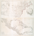
m
Amérique Septentrionale publi…
note:
…, gravh par le Sr.
Major
.
Amérique Septentrionale publi…
note:
…, gravh par le Sr.
Major
.
m
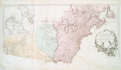
The provinces of New York, an…
note:
Appears in
Thomas
Jeffery's American atlas
The provinces of New York, an…
note:
drawn by
Major
Holland, Surveyor General