Click to visit the main New York Public Library Homepage
The New York Public Library
Digital Collections
About Digital Collections
Browse
Search only public domain materials
Items
Collections
Divisions
Home
Search
Browse
About
Search only public domain materials
Items
Collections
Divisions
Digital Collections
Using Images
Using Data
Search
Filtered keyword search
Show filters
Hide filters
Show Only Public Domain
topic
History
1
Indian land transfers
1
Land grants
1
Nautical charts
1
name
Brion de la Tour, Louis, 1743-1803
2
Esnauts et Rapilly
2
Alexander, James, 1691-1756
1
Barker, W. (William), active 1795-1803
1
Bond, Benjamin
1
More
Less
collection
x
Lawrence H. Slaughter Collection of English maps, charts, globes, books and atlases
place
Northeastern States
2
Delaware
1
Delaware -- Maps -- Early works to 1800
1
Delaware Bay (Del. and N.J.)
1
Delaware Bay (Del. and N.J.) -- Maps -- Early works to 1800
1
More
Less
genre
Maps
5
publisher
Chez Esnauts et Rapilly, rue St. Jacques à la Ville de Contances,
1
Chez Esnauts et Rapilly, rue St. Jacques à la Ville de Coutance
1
Dépôt de la marine
1
M. Carey,
1
Printed by James Parker, and a few Copies are to be Sold by him, and Benjamin Franklin, in Philadelphia;
1
division
Map Division
5
type
cartographic
5
Date Range
to
5 results found for:
x
Cape May
Filtering on:
x
Collection
: Lawrence H. Slaughter Collection of English maps, charts, globes, books and atlases
For more collection details, visit the
Lawrence H. Slaughter Collection of English maps, charts, globes, books and atlases collection page
.
Sort by:
Relevance
Title
Date created
Date digitized
Sequence
Delaware, from the best autho…
note:
… Moorestown to
Cape
May
.
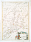
Carte du théatre de la guerre…
abstract:
Covers area from Quebec to
Cape
May
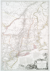
Carte du théatre de la guerre…
abstract:
… Quebec to
Cape
May
, N.J
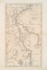
Carte de la baye et riviere d…
abstract:
… to Philadelphia, shows
Cape
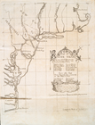
Map no. I : [to accompany A b…
note:
Covers area from Boston to
Cape
Hatteras