Click to visit the main New York Public Library Homepage
The New York Public Library
Digital Collections
About Digital Collections
Browse
Search only public domain materials
Items
Collections
Divisions
Home
Search
Browse
About
Search only public domain materials
Items
Collections
Divisions
Digital Collections
Using Images
Using Data
Search
Filtered search
Show filters
Hide filters
Show Only Public Domain
topic
Nautical charts
3
Coasts
2
Dredging
1
Rivers
1
name
Des Barres, Joseph F. W. (Joseph Frederick Wallet), 1729-1824
2
Kitchin, Thomas, 1718-1784
2
Bache, A. D. (Alexander Dallas), 1806-1867
1
Hassler, F. R. (Ferdinand Rudolph), 1770-1843
1
New York Times Company
1
More
Less
collection
Lawrence H. Slaughter Collection of English maps, charts, globes, books and atlases
3
Maps of New York City and State
3
place
New York (N.Y.)
4
New York (State)
4
East River (N.Y.)
2
Long Island (N.Y.)
2
Long Island Sound (N.Y. and Conn.)
2
More
Less
genre
Maps
6
publisher
Printed for R. Baldwin
2
Published for the use of the Royal Navy of Great Britain by Joseph F. W. Des Barres
2
Coast Survey
1
New York Times Company
1
division
Map Division
6
type
x
cartographic
Date Range
to
6 results found
Filtering on:
x
Title
: Exterior of Fort "Hell," Petersburg lines, Va., 1865
x
Type
: cartographic
Sort by:
Title
Date created
Date digitized
Sequence
Opening Hell Gate at a cost o…
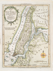
[A chart of New York Island &…
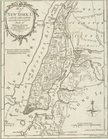
Map of New York I. : with the…
A chart of New York Island & …
Map of New York I. : with the…
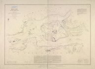
Hell Gate and its approaches