Click to visit the main New York Public Library Homepage
The New York Public Library
Digital Collections
About Digital Collections
Browse
Search only public domain materials
Items
Collections
Divisions
Home
Search
Browse
About
Search only public domain materials
Items
Collections
Divisions
Digital Collections
Using Images
Using Data
Search
Filtered search
Show filters
Hide filters
Show Only Public Domain
topic
Real property
1
name
G.W. Bromley & Co
1
collection
Atlases of New York City
1
place
New York (N.Y.)
1
Queens (New York, N.Y.)
1
genre
Cadastral maps
1
Maps
1
publisher
G. W. Bromley & Co
1
division
Map Division
1
type
cartographic
1
Date Range
to
1 result found
Filtering on:
x
Title
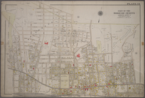
: Plate 34: Bounded by Bischoff Pl., Lott Lane, Flushing Avenue, Lathrop Avenue, Park Avenue, Highland Avenue, Grand Avenue, Hillside Avenue, (Jamaica Estates) Madison Avenue, (Long Island R.R.) Fulton Street, Vanderbilt Avenue, Archer Street, Vanwyck Avenue, Newtown Creek Road, Vanderbilt Avenue, Hancock Street, (Maple Grove Cemetery) Hoffman Blvd., Hutton Avenue & Knoll Avenue.
Sort by:
Title
Date created
Date digitized
Sequence
Plate 34: Bounded by Bischoff…