Click to visit the main New York Public Library Homepage
The New York Public Library
Digital Collections
About Digital Collections
Browse
Search only public domain materials
Items
Collections
Divisions
Home
Search
Browse
About
Search only public domain materials
Items
Collections
Divisions
Digital Collections
Using Images
Using Data
Search
Filtered keyword search
Show filters
Hide filters
Show Only Public Domain
topic
x
History
Real property
73
Business enterprises
67
Fortification
26
Railroads
13
More
Less
name
Beers, F. W. (Frederick W.)
67
American Civil War (1861-1865)
51
American Revolution (1775-1783)
21
United States. Army. Corps of Topographical Engineers
19
United States Coast Survey
14
More
Less
collection
Maps of North America
230
Atlases of the United States
67
Maps of New York City and State
21
Lawrence H. Slaughter Collection of English maps, charts, globes, books and atlases
9
The pictorial field-book of the War of 1812; or, Illustrations, by pen and pencil, of the history, biography, scenery, relics, and traditions of the last war for American independence
5
More
Less
place
United States
167
New York (State)
91
Virginia
86
Orange County
67
Orange County (N.Y.)
67
More
Less
genre
Maps
315
Atlases
67
Prints
37
Military maps
14
Illustrations
10
More
Less
publisher
Andreas, Baskin & Burr
67
publisher not identified
36
Corps of Topographical Engineers
10
U.S. Coast Survey Office
10
Harper & Brothers
9
More
Less
division
Map Division
327
Rare Book Division
7
Manuscripts and Archives Division
3
Milstein Division
3
Schomburg Jean Blackwell Hutson Research and Reference Division
3
More
Less
type
x
cartographic
text
8
still image
2
Date Range
to
348 results found for:
x
Passengers--United States
Filtering on:
x
Topic
: History
x
Type
: cartographic
Sort by:
Relevance
Title
Date created
Date digitized
Sequence
…
States
, east of the Rocky
note:
Shows
states
Historical sketch of the rebe…
note:
… by
United
States
forces
Eastern Tennessee, with parts…
abstract:
General map, without title.
State
names
m
History of the
United
States
note:
Includes inset map of the
United
States
.
…, with the
United
States
blockading
… & Southern
States
note:
… and boundaries of
states
.
Map illustrating the operatio…
collection:
United
States
Sanitary Commission records
… of the Southern
States
note:
…. for the
state
of Indiana."…
Map of the seat of war to acc…
note:
… of the southeastern
United
States
Map showing route of marches …
collection:
United
States
(except New York)…
Middle Virginia and North Car…
abstract:
… to highlight
state
boundaries
Plan of the siege of York Tow…
collection:
United
States
(except New York)…
A new military map of the sea…
note:
…,
state
boundaries
Statistical map of the
United
States
of America
abstract:
… are given for the
United
States
and individual
…
States
, including rail
collection:
United
States
(except New York)…
Map of York River, Virginia :…
collection:
United
States
(except New York)…
United
States
.
note:
Covers
United
States
as far west
Sketch exhibiting the approac…
collection:
United
States
(except New York)…
Military map of part of Georg…
collection:
United
States
(except New York)…
G. Woolworth Colton's map of …
note:
… and Gulf
states
" and list
m
… map of the
United
States
and Canadas
abstract:
…, towns, railroads,
state
… of the
United
States
note:
… of the
United
States
."…
Central Virginia : showing Li…
collection:
United
States
(except New York)…
Map of Camp Chase. Drawn on a…
collection:
United
States
Sanitary Commission records
m
Niagara 1819
note:
… the
United
States
The second section of the sur…
note:
… the
United
States
The army map of Georgia
collection:
United
States
(except New York)…
Gen. Washington's Revolutiona…
collection:
United
States
(except New York)…
Military map of part of Louis…
collection:
United
States
(except New York)…
Plan of the western seat of w…
collection:
United
States
(except New York)…
The route of the army under t…
collection:
United
States
(except New York)…
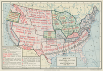
Status of slavery in the
United
States
, 1775-1865
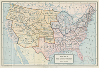
The
United
States
, March 4, 1855
J.H. Colton's topographical m…
abstract:
Subject: Map of the
states
of North Carolina
Loudon County, Virginia
collection:
United
States
(except New York)…
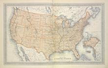
Map of The
United
States
collection:
Atlases of the
United
States
Plan of the siege of Savannah
collection:
United
States
(except New York)…
Plan of the battle fought nea…
abstract:
…
units
.
South-Carolina and parts adja…
note:
… to an independent
state
/ by David
Southern Mississippi and Alab…
abstract:
… of Mexico. This
state
lacks
Seat of war in Virginia : she…
collection:
United
States
(except New York)…
Plan of the siege of Charlest…
collection:
United
States
(except New York)…
An accurate map of Rhode Isla…
collection:
United
States
(except New York)…
Map of East Florida,: reduced…
collection:
United
States
(except New York)…
Attack of the rebels upon For…
collection:
United
States
(except New York)…
Lake St. Clair
note:
… by permission of the U.S.
State
Plan of the siege of Savannah…
collection:
United
States
(except New York)…
Florida, called by ye French …
note:
…
state
from Moll's Atlas
Map of Richmond, Virginia and…
collection:
United
States
(except New York)…
Military map refering to the …
collection:
United
States
(except New York)…
1
2
Previous
Next
1
2
Previous
Next