Click to visit the main New York Public Library Homepage
The New York Public Library
Digital Collections
About Digital Collections
Browse
Search only public domain materials
Items
Collections
Divisions
Home
Search
Browse
About
Search only public domain materials
Items
Collections
Divisions
Digital Collections
Using Images
Using Data
Search
Filtered keyword search
Show filters
Hide filters
Show Only Public Domain
topic
x
Administrative and political divisions
Railroads
84
Canals
35
Maps
17
Altitudes
13
More
Less
name
United States. General Land Office
35
Roeser, C. (Charles)
18
Bien, Julius, 1826-1909
17
Williamson, James Alexander, 1829-1902
14
Mitchell, S. Augustus (Samuel Augustus), 1792-1868
12
More
Less
collection
Maps of North America
137
Maps of New York City and State
75
Lawrence H. Slaughter Collection of English maps, charts, globes, books and atlases
2
place
New York (State)
77
New York (N.Y.)
17
Massachusetts
13
New Jersey
11
Connecticut
10
More
Less
genre
Maps
214
Topographic maps
5
Road maps
4
Wall maps
3
Aerial views
2
More
Less
publisher
General Land Office
18
Department of the Interior, General Land Office
13
S. Augustus Mitchell
12
publisher not identified
9
G.W. & C.B. Colton & Co
7
More
Less
division
Map Division
214
type
x
cartographic
still image
3
text
2
Date Range
to
214 results found for:
x
Bahia (Brazil : State)
Filtering on:
x
Topic
: Administrative and political divisions
x
Type
: cartographic
Sort by:
Relevance
Title
Date created
Date digitized
Sequence
State
of Mississippi …
State
of Indiana …
State
of Arkansas …
State
of Florida …
State
of Indiana …
State
of Iowa …
State
of Kansas …
The
state
of Connecticut
State
of Alabama …
State
of Iowa …
State
of Wisconsin …
State
of Oregon …
State
of Alabama …
note:
Map shows U.S. Land Office, capital of
state
State
of Florida
State
of Illinois …
State
of Ohio …
State
of Minnesota …
State
of Missouri …
State
of Louisiana …
The
state
of Florida …
State
of Indiana …
State
of Illinois …
State
of Oregon …
State
of Nebraska …
State
of Michigan …
State
of Nebraska …
State
of Missouri …
State
of Mississippi …
State
of Alabama …
State
of Minnesota …
State
of Colorado …
State
of Idaho …
State
of Wisconsin …
… the
state
of the surveys in the
state
of Florida …
abstract:
Subject: Map of the
state
of Florida showing
… the
state
of the surveys in the
state
of Florida …
The
state
of Rhode-Island …
Map of the
state
of Wisconsin …
m
Map of the
state
of Georgia
Map of the
state
of Missouri …
note:
… the auspices of the
State
Board
Map of the
state
of Wisconsin …
Map of the
state
of Kansas …
Map of the
state
of Florida …
Map of the
state
of Georgia …
Map of the
state
of Missouri …
Map of the
state
of Virginia
note:
…, Governor of the
state
State
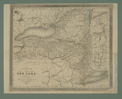
of New York
m
Map of the
state
of Virginia
note:
…, Governor of the
state
Map of the
state
of Georgia …
abstract:
… of the
state
; and profiles
m
The
State
of New York
note:
… the
state
and statistical
Map of the
state
of Alabama …