Click to visit the main New York Public Library Homepage
The New York Public Library
Digital Collections
About Digital Collections
Browse
Search only public domain materials
Items
Collections
Divisions
Home
Search
Browse
About
Search only public domain materials
Items
Collections
Divisions
Digital Collections
Using Images
Using Data
Search
Filtered keyword search
Show filters
Hide filters
Show Only Public Domain
topic
x
Administrative and political divisions
Ferries
2
Indian reservations
2
Landowners
2
Railroads
2
More
Less
name
Beers, F. W. (Frederick W.)
2
G.W. & C.B. Colton & Co
2
American Photo-Lithographic Company
1
Bailey, Gilbert Ellis, 1852-
1
Beers, Ellis & Soule
1
More
Less
collection
Maps of New York City and State
3
Maps of North America
3
place
New York
3
New York (State)
3
Brooklyn (New York, N.Y.)
2
Hoboken (N.J.)
2
Jersey City (N.J.)
2
More
Less
genre
Maps
6
Cadastral maps
1
Topographic maps
1
publisher
G.W. & C.B. Colton
2
Beers, Ellis & Soule
1
Department of the Interior, General Land Office
1
F.W. Beers, A.D. Ellis, and G.G. Soule
1
Louis Nell
1
division
Map Division
5
Manuscripts and Archives Division
1
type
cartographic
6
Date Range
to
6 results found for:
x
Thomsen-Ellis Co
Filtering on:
x
Topic
: Administrative and political divisions
Sort by:
Relevance
Title
Date created
Date digitized
Sequence
Nell's new topographical & to…
note:
…"Stone &
Co
., general agents
m
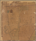
Map of the town of Morrisania, Westchester
Co
. N
collection:
Map of the town of Morrisania, Westchester
Co
Town of Ridgefield, Fairfield
Co
. Conn.
note:
….
Ellis
, and G.G. Soule
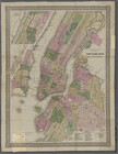
Territory of Wyoming
G. Woolworth Colton's new map…
abstract:
…'s Island,
Ellis
Island
G. Woolworth Colton's new map…
abstract:
…'s Island,
Ellis
Island