Click to visit the main New York Public Library Homepage
The New York Public Library
Digital Collections
About Digital Collections
Browse
Search only public domain materials
Items
Collections
Divisions
Home
Search
Browse
About
Search only public domain materials
Items
Collections
Divisions
Digital Collections
Using Images
Using Data
Search
Filtered keyword search
Show filters
Hide filters
Show Only Public Domain
topic
x
History
Fortification
18
Administrative and political divisions
5
Boundaries
5
Landowners
5
More
Less
name
American Civil War (1861-1865)
31
American Revolution (1775-1783)
14
United States Coast Survey
11
Krebs, Charles G
9
Lindenkohl, H. (Henry)
8
More
Less
collection
Maps of North America
106
Maps of New York City and State
11
Lawrence H. Slaughter Collection of English maps, charts, globes, books and atlases
3
History of Rome: From the building of the city to the ruin of the Republic
1
place
Virginia
58
United States
53
Richmond Region (Va.)
20
South Carolina
17
Richmond (Va.)
16
More
Less
genre
Maps
121
Military maps
9
Manuscript maps
4
Early works to 1800
3
Bathymetric maps
2
More
Less
publisher
publisher not identified
17
U.S. Coast Survey Office
8
U.S. Light-House Board
5
Corps of Engineers?
3
Harper and Bros
3
More
Less
division
Map Division
120
Pforzheimer Collection
1
type
x
cartographic
text
2
still image
1
Date Range
to
121 results found for:
x
17
Filtering on:
x
Topic
: History
x
Type
: cartographic
Sort by:
Relevance
Title
Date created
Date digitized
Sequence
Sketch of the Battle of Bunke…
note:
… of Bunker Hill on June
17
Countries adjacent to the Med…
Plan of the investment & atta…
Plan of the town of Boston wi…
collection:
… of Charlestown the
17
th of June
Map and plan to illustrate th…
Plan of the town of Boston an…
note:
…," vol.
17
, front. & p
Map of Brooklyn during the Ba…
Plan der Attaque, welche Sr. …
To accompany Willard's histor…
m
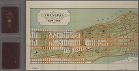
The Transval of New York
m
Map of Elizabeth City Co., Va…
first:
e
17
c9710-537f-0135-9cf3-39e97f969568
A new and accurate map of eas…
Map shewing the position of t…
note:
Scale approximately 1:
17
,000 (W 77°25ʹ59ʺ--W
A sketch of the environs of C…
first:
17
d670d0-5396-0135-d00b-7d36f48b861a
Map of York River, Virginia :…
Position of the American Army…
A sketch of the environs of C…
Plan of the seat of war : [Vi…
Map of part of the Shenandoah…
Approach of the Union Armies …
Attack on forts Clinton and M…
A plan of Charles Town, the c…
Octagonal map of the environs…
Parts of Ohio & Pennsylvania …
Plan of the siege of York Tow…
A sketch of the environs of C…
Map of the Sea-Coast of South…
parent:
3c1a
17
b0-4ee4-0135-d6e3-2bc9105a1073
Middle Virginia and North Car…
Sketch showing route of gener…
Battle of Long Island: from S…
Rhode - Island, 2e feuille
South-Carolina and parts adja…
Plan of York Town in Virginia…
Map of eastern Virginia
m
A sketch of the operations be…
Sketch exhibiting the approac…
To His Excellency Genl. Washi…
A carefully prepared map of t…
Plan of the action of Huberto…
Fortifications of Charleston …
A map and chart of those part…
Seat of war in Virginia : she…
m
Central Virginia
Position of the detachment un…
Plan of the siege of Charlest…
Position of Richmond, Va. : p…
Plan of the attack on forts C…
Military map of south-eastern…
m
Map of the environs of Peters…
An accurate map of Rhode Isla…