Click to visit the main New York Public Library Homepage
The New York Public Library
Digital Collections
About Digital Collections
Browse
Search only public domain materials
Items
Collections
Divisions
Home
Search
Browse
About
Search only public domain materials
Items
Collections
Divisions
Digital Collections
Using Images
Using Data
Search
Filtered keyword search
Show filters
Hide filters
Show Only Public Domain
topic
x
Railroads
Administrative and political divisions
86
Canals
52
Indian reservations
21
Postal service
20
More
Less
name
United States. General Land Office
20
United States. Post Office Department
18
Nicholson, W. L
15
G.W. & C.B. Colton & Co
14
Bien, Julius, 1826-1909
13
More
Less
collection
Maps of North America
157
Maps of New York City and State
52
Atlases of the United States
2
Maps of North and South America
1
place
New York (State)
56
United States
55
Massachusetts
18
New Jersey
16
Pennsylvania
15
More
Less
genre
Maps
212
Military maps
4
Road maps
3
Tourist maps
3
Aerial views
2
More
Less
publisher
Department of the Interior, General Land Office
11
Post Office Department
11
G.W. & C.B. Colton & Co
9
publisher not identified
9
General Land Office
7
More
Less
division
Map Division
212
type
x
cartographic
text
2
Date Range
to
212 results found for:
x
Yucatan (Mexico : State) -- History
Filtering on:
x
Topic
: Railroads
x
Type
: cartographic
Sort by:
Relevance
Title
Date created
Date digitized
Sequence
… of the United
States
,
Mexico
, and the
states
of Central America
note:
…. Taylor, United
States
… of the
state
of Texas, including part of
Mexico
Territory of New
Mexico
…
Territory of New
Mexico
…
…
States
, Canada and
Mexico
abstract:
… of the Atlantic coast
states
… of the
state
of Texas
…
States
, Canada and
Mexico
abstract:
… of the Atlantic coast
states
m
… of the United
States
abstract:
…
States
for the census
State
of Kansas …
United
States
note:
Shows settlements, railroads,
state
State
of Iowa …
State
of Kansas …
State
of Iowa …
State
of Wisconsin …
State
of Alabama …
note:
Map shows U.S. Land Office, capital of
state
State
of Louisiana …
State
of Nevada
State
of Oregon …
State
of Nevada
m
State
of Florida …
State
of Colorado …
State
of Wisconsin …
… of the territories of New
Mexico
Map of the
state
of Wisconsin …
Map of the Eastern
States
note:
… England
states
; shows
Map of the
state
of Virginia …
Map of the
state
of Wisconsin …
Map of the
state
of Kansas …
Map of the
state
of Florida …
Map of the
state
of Montana …
United
States
of America
Map of the
state
of Georgia …
abstract:
… of the
state
; and profiles
Map of the
state
of Florida …
note:
Issued by the
State
Board of Immigration.
A diagram of the
state
of Alabama
Map of the railroads of the
state
note:
…
states
, as well as post
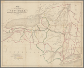
Map of the
State
of New-York
note:
… of neighboring
states
Map of the railroads of the
state
New map of the
state
of Minnesota …
Map of the railroads of the
state
Map of part of the
state
of Colorado
abstract:
…, Colorado, and New
Mexico
m
Colton's map of the
state
of Indiana …
Map of the
state
of New York
m
United
States
of America, 1834
County map of the
state
of California
Map of the railroads of the
state
note:
…
states
.
Map of the
state
of South Carolina …
A map of the New England
states
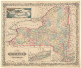
Map of the
State
of New York
note:
… of neighboring
states
Map of the
states
of California and Nevada …
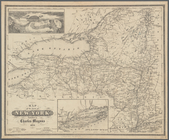
Map of the
State
of New York
note:
… of neighboring
states