Click to visit the main New York Public Library Homepage
The New York Public Library
Digital Collections
About Digital Collections
Browse
Search only public domain materials
Items
Collections
Divisions
Home
Search
Browse
About
Search only public domain materials
Items
Collections
Divisions
Digital Collections
Using Images
Using Data
Search
Filtered keyword search
Show filters
Hide filters
Show Only Public Domain
topic
Real property
298
Administrative and political divisions
178
Nautical charts
127
History
121
Railroads
112
More
Less
name
E.B. Hyde & Co
204
United States Coast Survey
139
Bache, A. D. (Alexander Dallas), 1806-1867
121
Hyde, Merritt B
118
Ullitz, Hugo
86
More
Less
collection
Maps of North America
846
Atlases of New York City
247
Atlases of the United States
177
Maps of New York City and State
70
Lawrence H. Slaughter Collection of English maps, charts, globes, books and atlases
40
More
Less
place
New York (State)
270
New York
159
Virginia
142
Pennsylvania
139
Suffolk County (N.Y.)
121
More
Less
genre
Maps
1454
Atlases
177
Nautical charts
117
Bathymetric maps
90
Cadastral maps
86
More
Less
publisher
E. Belcher Hyde
191
publisher not identified
92
U.S. Coast Survey
76
Sanborn Map Company
51
U.S. Coast Survey Office
42
More
Less
division
Map Division
1399
Manuscripts and Archives Division
24
Rare Book Division
10
Wallach Division: Print Collection
7
Schomburg Jean Blackwell Hutson Research and Reference Division
5
More
Less
type
x
cartographic
still image
44
text
33
Date Range
to
1,456 results found for:
x
17
Filtering on:
x
Type
: cartographic
Sort by:
Relevance
Title
Date created
Date digitized
Sequence
1841, showing the dates of th…
1899 Railroad map of Ohio
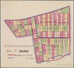
6th Senatorial District 10, 11,
17
Wards
A bird's-eye view of Narragan…
A bird's-eye view of the city…
A carefully prepared map of t…
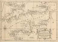
A chart of North and South Am…
note:
…
17
cm.
A chart of the English Channe…
m
A chart of the harbour of Rho…
A compleat map of North-Carol…
A compleat map of North-Carol…
m
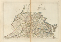
A correct map of the state of…
A correct map of Virginia
note:
In upper right corner:
17
.
A Danish Iron Mine
note:
Dobson
17
; Paulson 41; Tilden II:56a
A diagram of Oregon
A diagram of Oregon
A diagram of the State of Ala…
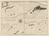
A draught of Port Royal Harbo…
A geographically correct map …
A geological and topographica…
A geological and topographica…
A geological and topographica…
A geological and topographica…
A geological map of the Black…
A map and chart of those part…
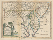
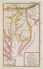
A map of Maryland with the De…
A map of Maryland with the De…
A map of part of Rhode Island…
A map of part of the Province…
A map of Philadelphia and par…
note:
Scale approximately 1:65,000 (W 75°
17
ʹ01ʺ--W
m
A map of Schuylkill County, P…
m
A map of South Carolina : wit…
m
A map of South Carolina : con…
m
A map of South Carolina and a…
m
A map of South Carolina and a…
A map of such parts of Georgi…
A map of that part of America…
A map of that part of America…
A Map of the British and Fren…
note:
… and pleasure, v.
17
, Oct. 1755.
A map of the city of Providen…
A map of the colonies of Conn…
A map of the Congo regions pu…
A map of the countrey of the …
A map of the country between …
A Map of the country round Ph…
m
A map of the Richmond & Alleg…
A map of the roads leading to…
A map of the state of Virgini…
A map of the states of Connec…
note:
Stokes 1821-F-
17
A map of the town of Providen…
1
2
3
4
5
6
Previous
Next
1
2
3
4
5
6
Previous
Next