Click to visit the main New York Public Library Homepage
The New York Public Library
Digital Collections
About Digital Collections
Browse
Search only public domain materials
Items
Collections
Divisions
Home
Search
Browse
About
Search only public domain materials
Items
Collections
Divisions
Digital Collections
Using Images
Using Data
Search
Filtered keyword search
Show filters
Hide filters
Show Only Public Domain
topic
Lighthouses
1
Nautical charts
1
name
Andrew B. Graham Co
1
Bache, A. D. (Alexander Dallas), 1806-1867
1
Benner, F. W
1
Bouquet, Henry, 1719-1765
1
Clarkson, Matthew, 1733-1800
1
More
Less
collection
Maps of North America
3
Bancker plans
1
Maps of New York City and State
1
place
Louisiana
2
Florida
1
Fort Pike (La.)
1
Fort Pike Region (La.)
1
Georgia
1
More
Less
genre
Maps
5
Nautical charts
1
Surveys
1
land surveys
1
publisher
Mathew Clarkson
1
T. and J. Swords?
1
U.S. Coast Survey Office
1
U.S. Light-House Board
1
division
Map Division
4
Manuscripts and Archives Division
1
type
x
cartographic
Date Range
to
5 results found for:
x
630
Filtering on:
x
Type
: cartographic
Sort by:
Relevance
Title
Date created
Date digitized
Sequence
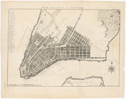
Plan of the city of New York
note:
Haskell. Manhattan maps,
630
A general chart of all the co…
note:
….
630
m
Lots between Delancey and Riv…
note:
Lot numbers
630
-633.
Preliminary chart of the Rigo…
Sixth l. h. district
note:
… River [Scale 1:
630