Click to visit the main New York Public Library Homepage
The New York Public Library
Digital Collections
About Digital Collections
Browse
Search only public domain materials
Items
Collections
Divisions
Home
Search
Browse
About
Search only public domain materials
Items
Collections
Divisions
Digital Collections
Using Images
Using Data
Search
Filtered keyword search
Show filters
Hide filters
Show Only Public Domain
topic
Canals
1
Ferries
1
Fire alarms
1
Nautical charts
1
Railroads
1
More
Less
name
A. Brown & Co
1
Bennet, Thomas, -1706
1
Brion de la Tour, Louis, -1823
1
De Witt, Simeon, 1756-1834
1
Fairman, Gideon, 1774-1827
1
More
Less
collection
Lawrence H. Slaughter Collection of English maps, charts, globes, books and atlases
3
Maps of New York City and State
1
The history of Dahomy, an inland Kingdom of Africa
1
place
New York (State)
2
Atlantic Ocean
1
Benin (Kingdom)
1
Brooklyn
1
Brooklyn (New York, N.Y.)
1
More
Less
genre
Maps
5
Illustrations
1
publisher
A. Brown & Co
1
Author
1
T. Bennet [etc.]
1
[S. De Witt?],
1
s.n
1
division
Map Division
4
Schomburg Manuscripts, Archives and Rare Books Division
1
type
x
cartographic
Date Range
to
5 results found for:
x
801
Filtering on:
x
Type
: cartographic
Sort by:
Relevance
Title
Date created
Date digitized
Sequence
m
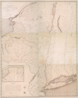
Map of the state of New York
note:
Lawrence H. Slaughter Collection ;
801
.
A new generall chart for the …
Carte de la Nouvelle York : y…
note:
Lawrence H. Slaughter Collection ;
801
.
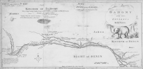
Dahomy and its environs by R.…
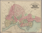
Map of the consolidated city …