Click to visit the main New York Public Library Homepage
The New York Public Library
Digital Collections
About Digital Collections
Browse
Search only public domain materials
Items
Collections
Divisions
Home
Search
Browse
About
Search only public domain materials
Items
Collections
Divisions
Digital Collections
Using Images
Using Data
Search
Filtered keyword search
Show filters
Hide filters
Show Only Public Domain
topic
Administrative and political divisions
2
Buildings
2
Fire protection districts
2
Piers
2
Brooklyn (New York, N.Y.)--Maps
1
More
Less
name
Atwood, John M., approximately 1818-
3
Ensign, Thayer & Co
2
B.W. Thayer & Co
1
Dana, James, 1811-1890
1
Ensign & Bridgman
1
More
Less
collection
Maps of New York City and State
3
Maps of North America
2
place
Brooklyn (New York, N.Y.)
2
Jersey City (N.J.)
2
Manhattan (New York, N.Y.)
2
New York
2
New York (N.Y.)
2
More
Less
genre
Maps
5
Cadastral maps
1
Tourist maps
1
publisher
Ensign, Thayer & Co
2
Ensign & Bridgman
1
Ensign & Thayer, 50 Ann Street
1
publisher not identified
1
division
Map Division
5
type
x
cartographic
Date Range
to
5 results found for:
x
B.W. Thayer and Co
Filtering on:
x
Type
: cartographic
Sort by:
Relevance
Title
Date created
Date digitized
Sequence
Plan of lots on Bunker Hill
parent:
bac116a0-
b
143-0132-83cb-58d385a7bbd0
Phelps's national map of the …
parent:
f58affb0-c52a-012f-56dd-3c075448cc4
b
Fanning's map of New-York Cit…
first:
cc4088c0-f3a1-0130-770f-58d385a7
b
928
m
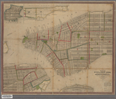
Map of the City of New York w…
parent:
5784cca0-ed72-0130-5
b
0d-58d385a7bbd0
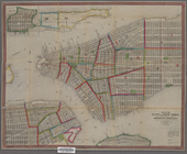
Map of the City of New York w…
first:
f8ef7a70-f39e-0130-e83d-58d385a7
b
928