Click to visit the main New York Public Library Homepage
The New York Public Library
Digital Collections
About Digital Collections
Browse
Search only public domain materials
Items
Collections
Divisions
Home
Search
Browse
About
Search only public domain materials
Items
Collections
Divisions
Digital Collections
Using Images
Using Data
Search
Filtered keyword search
Show filters
Hide filters
Show Only Public Domain
topic
Real property
5
Nautical charts
2
name
G.W. Bromley & Co
3
Holland, N., Captain
2
Laurie & Whittle
2
Deetjen, A
1
Fairchild, John F
1
More
Less
collection
Atlases of the United States
5
Lawrence H. Slaughter Collection of English maps, charts, globes, books and atlases
3
Cartographic materials from the Emmet collection of manuscripts etc. relating to American history
1
Maps of New York City and State
1
place
New York (State)
5
Westchester County
4
Westchester County (N.Y.)
4
Atlantic Coast (U.S.)
2
Maps
2
More
Less
genre
Maps
10
Atlases
5
Advertisements
1
Aerial views
1
publisher
G.W. Bromley & Co
3
Rob[er]t Laurie & James Whittle, No. 53 Fleet Street
2
s.n
2
A.J. Fisher
1
Fairchild, John F
1
division
Map Division
10
type
x
cartographic
still image
1
text
1
Date Range
to
10 results found for:
x
Fisher, S
Filtering on:
x
Type
: cartographic
Sort by:
Relevance
Title
Date created
Date digitized
Sequence
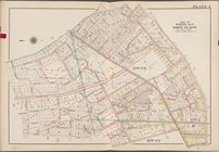
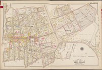
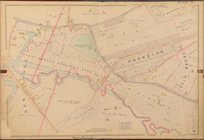
… [Map bounded by
Fisher
collection:
…. and W.
S
. Bromley
….,
Fisher
Ave., Bank St.]
collection:
…. and W.
S
. Bromley
….,
Fisher
Ave., Linden Pl.]
collection:
…. and W.
S
. Bromley
m
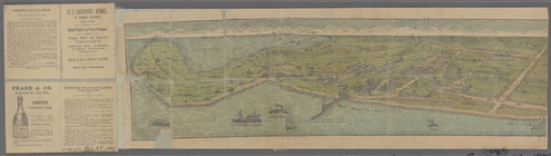
Birdseye view of Coney Island…
A chart of Delaware Bay and R…
note:
from the original by Mr.
Fisher
Part of North America: compre…
note:
… for William
Fisher
m
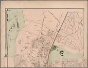
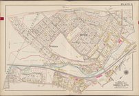
Plates 17 & 18: Fordham, Town…
note:
… and
Fisher
Farm.
A new and accurate chart (fro…
note:
…, Rob[er]t Laurie and Ja[me]
s
A new and accurate chart (fro…
note:
…, Rob[er]t Laurie and Ja[me]
s
… [Map bounded by
S
. 3rd