Click to visit the main New York Public Library Homepage
The New York Public Library
Digital Collections
About Digital Collections
Browse
Search only public domain materials
Items
Collections
Divisions
Home
Search
Browse
About
Search only public domain materials
Items
Collections
Divisions
Digital Collections
Using Images
Using Data
Search
Filtered keyword search
Show filters
Hide filters
Show Only Public Domain
topic
Administrative and political divisions
58
Nautical charts
58
Railroads
58
Indian reservations
31
Postal service
31
More
Less
name
United States Coast Survey
59
Bache, A. D. (Alexander Dallas), 1806-1867
54
United States. General Land Office
47
Nicholson, W. L
36
United States. Post Office Department
31
More
Less
collection
Maps of North America
277
Maps of New York City and State
36
Lawrence H. Slaughter Collection of English maps, charts, globes, books and atlases
28
Voyage de la corvette l'Astrolabe exécuté par ordre du roi: pendant les années 1826-1827-1828-1829
8
Atlases of New York City
6
More
Less
place
New York (State)
44
United States
38
North America
28
Massachusetts
23
Virginia
23
More
Less
genre
Maps
393
Nautical charts
52
Bathymetric maps
33
Cadastral maps
15
Illustrations
8
More
Less
publisher
Department of the Interior, General Land Office
21
U.S. Coast Survey
21
U.S. Coast Survey Office
21
General Land Office
20
Post Office Department
17
More
Less
division
Map Division
366
General Research Division
16
Rare Book Division
7
Schomburg Manuscripts, Archives and Rare Books Division
5
Schomburg Jean Blackwell Hutson Research and Reference Division
3
More
Less
type
x
cartographic
still image
7
text
5
Date Range
to
398 results found for:
x
L. C
Filtering on:
x
Type
: cartographic
Sort by:
Relevance
Title
Date created
Date digitized
Sequence
John Garwood, Bushville Mills…
parent:
f0fe4760-
c
5f7-012f-4
c
52-58d385a7bc34
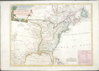
Nouveau Mexique, Louisiane, C…
parent:
93a27970-
c
52a-012f-6829-3
c
075448cc4b
California (Los Angeles Co.) …
parent:
42cc38b0-
c
52b-012f-4adf-3
c
075448cc4b
Map of Wilmington Harbor, Cal…
parent:
90fca0d0-1347-0136-7fd8-0d1
c
3cbd1
c
25
City of Spokane Falls, Washin…
parent:
8dc7cd10-2
c
69-0136-82d9-35d388f47
c
37
… de
l
' océan
parent:
e41aed50-
c
5fe-012f-afb6-58d385a7bc34
… Canada &
c
.
parent:
f1e739a0-
c
62
c
-012f-508f-58d385a7bc34
Plan, de
l
' île
parent:
e50ff9
c
0-
c
5fe-012f-40cc-58d385a7bc34
Alaska Peninsula and Aleutian…
parent:
d4fe8590-b142-0132-d8
c
1-58d385a7bbd0
Carte pour
l
' intelligence du mémoire de m
parent:
e3
c
14680-
c
5fe-012f-7d72-58d385a7bc34
… Florida &
c
.
parent:
f2327940-
c
62
c
-012f-06a2-58d385a7bc34
Map of Chenango County, New Y…
parent:
707eb280-cd12-0133-ce8d-00505686a51
c
William
C
. Smead
parent:
0dc8cc00-
c
5f8-012f-e389-58d385a7bc34
…. M.
l
' Astrolabe
parent:
e46f6cf0-
c
5fe-012f-08
c
9-58d385a7bc34
… corvette de S. M.
l
parent:
e562f030-
c
5fe-012f-e160-58d385a7bc34
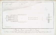
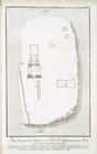
Plan de
l
'Isle de Rodda, avec ses Environs.
parent:
19ad3470-
c
6ba-012f-5340-58d385a7bc34
Map of the world
parent:
c
7dcdad0-
c
606-012f-5325-58d385a7bc34
Map of India
parent:
c
83316b0-
c
606-012f-f354-58d385a7bc34
Map of Gallia (France)
parent:
19
c
076b0-
c
604-012f-12a6-58d385a7bc34
m
Hammond's standard map of the…
parent:
04a42
c
90-f39
c
-0130-fe2e-58d385a7b928
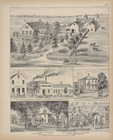
Shonnard Park at Yonkers, est…
parent:
9010a670-25d3-0134-1723-00505686a51
c
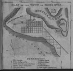
Plan of the Town of Monrovia
parent:
7de0
c
840-
c
608-012f-b01a-58d385a7bc34
… colossales,
c
. Portail, d
parent:
3b43ae70-
c
6ba-012f-f083-58d385a7bc34
Plan des superbes edifices sur
l
'Isle Ell
parent:
49d258e0-
c
6ba-012f-f894-58d385a7bc34
Res. of
C
. B
parent:
f34
c
2a30-
c
5f7-012f-8e64-58d385a7bc34
Map of the boundary between t…
parent:
2cddb440-8b1b-0133-f7ad-00505686a51
c
Map of the Colony of Liberia …
parent:
7d7b27e0-
c
608-012f-edda-58d385a7bc34
… Palais de Memnon, dans
l
parent:
3f0d6f70-
c
6ba-012f-1a67-58d385a7bc34
… & other railroads &
c
. &
c
.
parent:
3a516450-
c
0b5-0134-
c
4ca-00505686a51
c
Herman Schaffer, esq.: Knollw…
parent:
a1e807f0-356
c
-0134-5559-00505686a51
c
m
…, by order of John
C
. R. Eckerson, Oliver
L
. Jones
parent:
c
5e77850-32
c
0-0131-7038-58d385a7bbd0
Alaska Peninsula and Aleutian…
parent:
d73f7
c
10-ed97-0135-8755-332a5039146f
Map of Philadelphia photograp…
parent:
cfa834
c
0-bb5e-0135-ca2f-47117f9eb727
…. Jean,
l
'Acadie &
c
.
parent:
46d33510-
c
5d5-012f-2e78-58d385a7bc34
… Work, &
c
. ; Res
parent:
b8
c
82f80-
c
5f7-012f-6e28-58d385a7bc34
Assemblage de
l
' atlas Suisse.
parent:
775eb2e0-
c
6e7-012f-e82a-58d385a7bc34
Preliminary chart of Gloucest…
parent:
8cc893
c
0-52aa-0134-1483-00505686a51
c
Map of Philadelphia photograp…
parent:
21f28500-bb48-0135-52
c
6-004d171ac8a0
Partie de la Valteline et frontiere de
l
parent:
7b97d790-
c
6e7-012f-385
c
-58d385a7bc34
Mouth of Chester River : (Har…
parent:
54
c
27df0-
c
52b-012f-8018-3
c
075448cc4b
William
L
. Bamber's Marble & Granite Works 30
parent:
103d86b0-
c
5ed-012f-
c
17e-58d385a7bc34
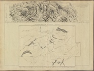
Geological and topographical …
parent:
627654
c
0-a090-0135-a738-13fb7fe8286b
The Caron map of the city of …
parent:
344a1ec0-3d76-0135-1d2
c
-47d3906633dd
… by Avenue
C
, Ralph Avenue, Avenue
L
, Ocean Avenue
parent:
b4534410-
c
604-012f-25
c
6-58d385a7bc34
Map of the battle fields of t…
parent:
0
c
56fe10-76e3-0135-e25b-1189745
c
43f5
m
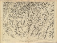
Map of the Department of the …
parent:
e0aa70a0-9eee-0134-886e-00505686a51
c
Map of Byram River from its m…
parent:
41bdda20-
c
5aa-012f-4dde-58d385a7bc34
Boston Harbor, Massachusetts
parent:
01155650-97e5-0134-2547-00505686a51
c
…. ; E.
L
. & G. D. Kenyon
parent:
f1d20f80-
c
5f7-012f-91a0-58d385a7bc34
Map of the water region: adja…
parent:
d21fb2f0-97df-0134-9bb7-00505686a51
c
1
2
Previous
Next
1
2
Previous
Next