Click to visit the main New York Public Library Homepage
The New York Public Library
Digital Collections
About Digital Collections
Browse
Search only public domain materials
Items
Collections
Divisions
Home
Search
Browse
About
Search only public domain materials
Items
Collections
Divisions
Digital Collections
Using Images
Using Data
Search
Filtered keyword search
Show filters
Hide filters
Show Only Public Domain
topic
Real property
5
Administrative and political divisions
2
History
1
Landowners
1
name
Beers, D. G. (Daniel G.)
6
King, Harry (Draftsman)
2
Lamoreux, Silas W
2
O'Hare, Daniel
2
United States. General Land Office
2
More
Less
collection
Atlases of the United States
5
Maps of North America
3
Maps of New York City and State
1
place
New York (State)
6
Jefferson County (N.Y.)
5
Alabama
1
Louisiana
1
Ontario County
1
More
Less
genre
Maps
9
Atlases
5
publisher
C.K. Stone
5
A.R.Z. Dawson
1
Department of the Interior, General Land Office
1
General Land Office, Dept. of the Interior
1
Office of Maps and Surveys, Army of the Potomac
1
division
Map Division
9
type
x
cartographic
still image
1
Date Range
to
9 results found for:
x
O'Connell, Daniel
Filtering on:
x
Type
: cartographic
Sort by:
Relevance
Title
Date created
Date digitized
Sequence
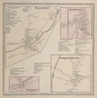
Map of a portion of Virginia:…
note:
Gift; Mrs.
Daniel
Butterfield 1903-1904
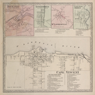
State of Alabama
note:
… Division G.L.
O
. ; revised and drawn by
Daniel
O
Map of the State of Louisiana…
note:
… and drawn by
Daniel
O
'Hare.
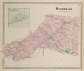
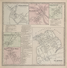
Pillar Point P.
O
. [Village]; Brownville
…. ; Woodville ( P.
O
.) [Village
…. ; St. Lawrence ( P.
O
Ellisburgh P.
O
…. ;Sanford's Cors. ( P.
O
m
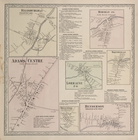
Map of Ontario County, New Yo…
note:
… Treat, A.Y. Peck, C.
O