Click to visit the main New York Public Library Homepage
The New York Public Library
Digital Collections
About Digital Collections
Browse
Search only public domain materials
Items
Collections
Divisions
Home
Search
Browse
About
Search only public domain materials
Items
Collections
Divisions
Digital Collections
Using Images
Using Data
Search
Filtered keyword search
Show filters
Hide filters
Show Only Public Domain
topic
Real property
8
Parks
5
Landowners
3
Administrative and political divisions
2
Maps
2
More
Less
name
G.W. Bromley & Co
4
E. Sachse & Co
2
Parke, John G
2
Shipley, Wm. H. (William H.)
2
Smith, Isaac W. (Isaac William), 1825-1898
2
More
Less
collection
Atlases of New York City
15
Maps of North America
8
Maps of New York City and State
7
Atlases of the United States
3
place
New York (State)
10
New York (N.Y.)
9
Manhattan (New York, N.Y.)
6
Bronx (New York, N.Y.)
4
Baltimore (Md.)
2
More
Less
genre
Maps
33
Cadastral maps
4
Atlases
3
Diagrams
1
Illustrations
1
More
Less
publisher
G.W. Bromley & Co
3
Commission?
2
Perris & Browne
2
War Department
2
E. Belcher Hyde
1
More
Less
division
Map Division
33
type
x
cartographic
still image
2
Date Range
to
33 results found for:
x
Parks, John W.
Filtering on:
x
Type
: cartographic
Sort by:
Relevance
Title
Date created
Date digitized
Sequence
m
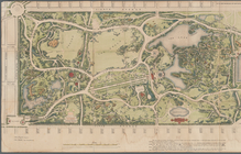
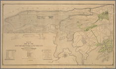
Map of the Central
Park
note:
…"
John
Bogart, engineer, Otto Sibeth, topo
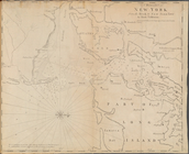
Sketch map of the city of New…
note:
…,
W.W
. Niles,
John
…, railroads, etc /
John
note:
… in 1876 by
John
Disturnell
New and enlarged map of Balti…
note:
… to the inch (
W
76°42ʹ40ʺ--
W
… to the
parks
/ selected
note:
…,
W.W
. Niles,
John
m
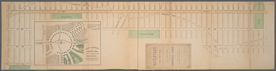
Highwood
Park
, East of Glenwood Ave., at Tenafly
note:
by L.
W
. Post,
John
Camp, surveyors.
… Lane,
John
Street
New and enlarged map of Balti…
note:
… in the year 1871 by
John
F
… Lane,
W
. 7th St., S
note:
…
John
F. Fairchild.
… (Central
Park
West),
W
note:
laid out by
John
Randel, jr., 1819-20
…,
John
Street, Fulton
Bounded by
W
. 77th Street, (Central
Park
note:
laid out by
John
Randel, jr., 1819-20
Bounded by
W
. 73rd
note:
laid out by
John
Randel, jr., 1819-20
Bounded by
W
. 115th Street (Morningside
Park
note:
laid out by
John
Randel, jr., 1819-20
Bounded by
W
. 135th
note:
laid out by
John
Randel, jr., 1819-20
…
Park
Hartsdale Rd., Summit Ave.,
John
St
m
….
John
H. Delaney
note:
Park
Ave (E41st-E42nd Sts),
W
Broadway
Bounded by
W
. 131st
note:
laid out by
John
Randel, jr., 1819-20
PBounded by
W
. 93rd Street (Yorkville),
Park
note:
laid out by
John
Randel, jr., 1819-20
Bounded by
W
. 114th Street, Fourth (
Park
note:
laid out by
John
Randel, jr., 1819-20
… by the Commissioners of Fairmount
Park
…
note:
… ft. to an inch (
W
75°13ʹ48ʺ--
W
75°11ʹ24ʺ/N
m
… to Central
Park
, with grades
note:
Scale not given (
W
73°59ʹ46ʺ--
W
73°56ʹ13ʺ/N
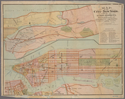
New and improved map of the c…
note:
… publisher's name with "
John
… Point,
John
F. Lee Map
note:
by George
W
. and Walter S. Bromley.
General map of explorations a…
note:
… by Lieut. J.G.
Parke
, Topl
Map and profile of the Tejon …
note:
… by Lieut. J.G.
Parke
, Topl
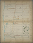
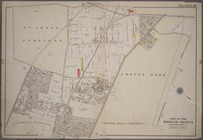
…, Forest
Park
, Lott Ave
collection:
….,
John
St.; Including
A Draught of New York from th…
note:
… and
John
Livingston
m
Map of Cook County, Illinois
note:
… surveys by
W
.L. Flower.
… Street; Including St.
John
Park
, Worth Street
….
Johns
Cemetery), Forest
Park
, (Cypress Hill
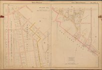
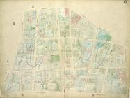
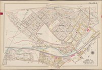
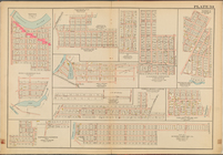
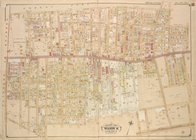
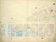
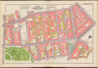
Double Page Plate No. 24, Par…
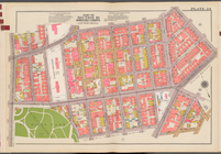
Double Page Plate No. 24, Par…
End of results
|
Top