Click to visit the main New York Public Library Homepage
The New York Public Library
Digital Collections
About Digital Collections
Browse
Search only public domain materials
Items
Collections
Divisions
Home
Search
Browse
About
Search only public domain materials
Items
Collections
Divisions
Digital Collections
Using Images
Using Data
Search
Filtered keyword search
Show filters
Hide filters
Show Only Public Domain
topic
Real property
386
Nautical charts
76
Railroads
67
Administrative and political divisions
46
Landowners
46
More
Less
name
Pidgeon, R. H. (Roger H.)
364
E. Robinson Co
312
Robinson, E. (Elisha)
263
United States Coast Survey
67
Bache, A. D. (Alexander Dallas), 1806-1867
61
More
Less
collection
Atlases of New York City
304
Atlases of the United States
223
Maps of New York City and State
196
Maps of North America
175
Lawrence H. Slaughter Collection of English maps, charts, globes, books and atlases
15
More
Less
place
New York (State)
465
New York (N.Y.)
313
New York
249
New Jersey
109
Brooklyn (New York, N.Y.)
72
More
Less
genre
Maps
936
Atlases
223
Nautical charts
60
Cadastral maps
33
Bathymetric maps
30
More
Less
publisher
E. Robinson Co
264
E. Robinson
49
J.M. Lathrop & Company
37
Bien, Joseph R
35
I.B. Culver & Co
32
More
Less
division
Map Division
923
Schomburg Jean Blackwell Hutson Research and Reference Division
6
Wallach Division: Print Collection
6
General Research Division
4
Milstein Division
2
More
Less
type
x
cartographic
text
13
still image
9
Date Range
to
945 results found for:
x
R. N
Filtering on:
x
Type
: cartographic
Sort by:
Relevance
Title
Date created
Date digitized
Sequence
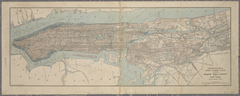
Map of New York City and vici…
note:
… 73°42ʹ00ʺ/
N
40°54ʹ58ʺ--
N
Map of the Iron Cliffs Co.'s …
note:
… 87°47ʹ--W 87°20ʹ/
N
46°38ʹ--
N
46°21ʹ).
… ;
R
. D. Servoss, Eng'
r
,
N
. Y.
note:
… 73°51ʹ29ʺ/
N
40°54ʹ36ʺ--
N
The Cord Meyer Development Co…
note:
… 73°47ʹ17ʺ/
N
40°50ʹ48ʺ--
N
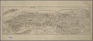
Map of Manhattan and part of …
note:
…"Copyright 1904 by A.
R
. Ohman."…
Map showing the lands assigne…
note:
… 103°--W 90°/
N
44°--
N
Map of New York City and vici…
note:
… 73°42ʹ00ʺ/
N
40°54ʹ58ʺ--
N
m
Fair Street, Ann Street and B…
note:
…. Includes
N
. Fletcher's land. Also James
R
. Smith
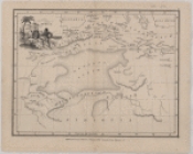
Africa
A new map of Africa from the …
…, Saratoga. Co.,
N
.Y
collection:
…, Saratoga. Co.,
N
m
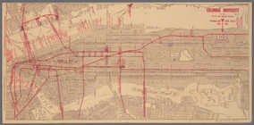
Columbia University in the Ci…
note:
… 74°01ʹ19ʺ--W 73°55ʹ11ʺ/
N
40°48ʹ45ʺ--
N
40°41ʹ42ʺ).
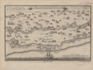
A map of the Kingdom of Whidah
Map of Cincinnati and suburbs…
note:
… 84°25ʹ16ʺ/
N
39°10ʹ25ʺ--
N
… Street,
N
. Eleventh Street,Driggs Street,
N
collection:
… Street,
N
. Eleventh Street,Driggs Street,
N
. Ninth
m
The Centennial--balloon view …
note:
…ʹ10ʺ/
N
40°00ʹ12ʺ--
N
… by
N
. Second Street, Kent Avenue,
N
. Third
m
Map of the metropolitan distr…
note:
… 73°42ʹ00ʺ/
N
40°54ʹ58ʺ--
N
Design map of the village of …
note:
… 104°58ʹ/
N
39°15ʹ--
N
39°15
Bird's eye view of Philadelph…
note:
…ʹ56ʺ/
N
39°58ʹ52ʺ--
N
A map of Philadelphia and par…
note:
By
N
. Scull and G. Heap.
….
N
. Brayton, South Wales,
N
.Y. ; Res. of
R
… Central & Hudson River
R
.
R
. / printed
note:
…ʹ39ʺ/
N
40°51ʹ28ʺ--
N
m
… [cartographic material] /
R
note:
…ʹ20ʺ/
N
40°44ʹ30ʺ--
N
Lots & blocks shaded red belo…
note:
… 87°37ʹ--W 87°35ʹ/
N
41°53ʹ--
N
41°53ʹ).
m
City of New York, boroughs of…
note:
…"Copyright 1906, by August
R
. Ohman."…
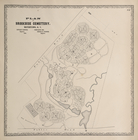
… Cemetery, Watertown,
N
.Y
note:
by S.
N
. & D.G. Beers and assistants.
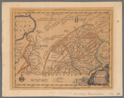
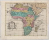
A new and accurate map of Afr…
note:
R
. W. Seale sculp.
H. Kiepert's physikalische Wa…
note:
… (E 168°--W 2°/
N
83°--
N
1°)…
m
Kentucky and Tennessee
note:
…ʹ/
N
39°30ʹ--
N
34°30ʹ).
Military topographical map of…
note:
…. 1864 by
R
. Chauncy ..."…
Map showing the distribution …
note:
…ʹ/
N
41°20ʹ--
N
39°00ʹ).
…, in T 58
N
.
R
. 30 W.
note:
… 88°18ʹ--W 87°48ʹ/
N
47°30ʹ--
N
47°22ʹ).
m
Map of New York City (Manhatt…
note:
… of each page: "
R
.D. Servoss,
N
.Y."…
m
… of Westchester County
N
.Y. …
note:
… 73°43ʹ09ʺ/
N
40°59ʹ58ʺ--
N
The United States according t…
note:
…. 1:3,200,000] (W 95°--W 59°/
N
47°--
N
29°)…
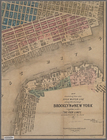
Map of the borough of Brookly…
note:
… 74°02ʹ18ʺ--W 73°52ʹ13ʺ/
N
40°44ʹ24ʺ--
N
40°33ʹ59ʺ).
m
A map of the province of Pens…
note:
…. 1:2,650,000] (W 81̕--W 74̕/
N
43̕--
N
39̕).
m
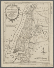
Map of New York I. : with the…
note:
…] (W 74⁰03ʹ--W 73⁰50ʹ/
N
40⁰52ʹ--
N
40⁰40ʹ)…
m
… County,
N
.Y.
note:
…ʹ/
N
40°56ʹ--
N
40°47ʹ)…
H Diagram of the state of Mis…
note:
… 95°46ʹ--W 89°05ʹ/
N
40°36ʹ--
N
35°59ʹ).
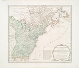
The United States of America …
collection:
I.
N
. Phelps Stokes Collection of American
Southern provinces of the Uni…
Higgins' map of St. Louis and…
note:
…ʹ/
N
39°00ʹ--
N
38°23ʹ).
A map of the Manor Renselaerw…
note:
… (W 74°16ʹ--W 73°16ʹ/
N
42°50ʹ--
N
42°28ʹ).
…., Brook Ave.,
N
. Third Ave
… bounded by
N
. 6th St
… bounded by
N
. 13th St
collection:
… bounded by
N
. 13th St., 2
Map of the state of Missouri …
note:
… (W 95°46ʹ--W 89°05ʹ/
N
40°36ʹ--
N
35°59ʹ).
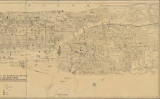
Sketch map of the city of New…
note:
…ʹ29ʺ/
N
40°54ʹ36ʺ--
N
1
2
3
4
Previous
Next
1
2
3
4
Previous
Next