Click to visit the main New York Public Library Homepage
The New York Public Library
Digital Collections
About Digital Collections
Browse
Search only public domain materials
Items
Collections
Divisions
Home
Search
Browse
About
Search only public domain materials
Items
Collections
Divisions
Digital Collections
Using Images
Using Data
Search
Filtered keyword search
Show filters
Hide filters
Show Only Public Domain
topic
Nautical charts
4
Landowners
2
Administrative and political divisions
1
Real property
1
Villages
1
name
Fisher, Joshua, 1707-1783
2
Smith, Robert Pearsall, 1827-1898
2
Bache, A. D. (Alexander Dallas), 1806-1867
1
Balch, E. A
1
Daser, L
1
More
Less
collection
Lawrence H. Slaughter Collection of English maps, charts, globes, books and atlases
3
Maps of New York City and State
2
Maps of North America
2
place
Delaware Bay (Del. and N.J.)
3
Delaware
2
Delaware River Estuary
2
Early works to 1800
2
Maps
2
More
Less
genre
Maps
7
Cadastral maps
1
Nautical charts
1
publisher
E.A. Balch
1
Gillett, Matthews & Co
1
Printed and published by Robert Laurie and James Whittle, No. 53, Fleet Street ..
1
Printed for Robert Sayer, map & sea chartseller, No. 53 Fleet Street
1
Printed for Robt. Sayer & Jno. Bennett, map & sea chart sellers, No. 53 Fleet Street
1
More
Less
division
Map Division
7
type
x
cartographic
Date Range
to
7 results found for:
x
Sands, Robert
Filtering on:
x
Type
: cartographic
Sort by:
Relevance
Title
Date created
Date digitized
Sequence
Biloxi Bay, Mississippi : fro…
note:
… of Lieut. B.F.
Sands
, U.S.N
Part of North America: compre…
collection:
…, rocks, shoals,
sands
…, soundings, shoals,
sands
…, soundings, shoals,
sands
…, soundings, shoals,
sands
m
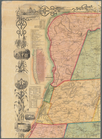
Map of Rensselaer County, New…
note:
… in the year 1854 by
Robert
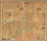
Map of Oswego County, New Yor…
note:
… in the year 1854 by
Robert