Click to visit the main New York Public Library Homepage
The New York Public Library
Digital Collections
About Digital Collections
Browse
Search only public domain materials
Items
Collections
Divisions
Home
Search
Browse
About
Search only public domain materials
Items
Collections
Divisions
Digital Collections
Using Images
Using Data
Search
Filtered keyword search
Show filters
Hide filters
Show Only Public Domain
topic
Real property
31
Railroads
20
Landowners
11
Administrative and political divisions
10
Explorations and surveys
8
More
Less
name
E. Robinson Co
24
Pidgeon, R. H. (Roger H.)
20
Robinson, E. (Elisha)
15
Warren, G. K. (Gouverneur Kemble), 1830-1882
5
Bien, Julius, 1826-1909
4
More
Less
collection
Maps of North America
47
Atlases of New York City
24
Maps of New York City and State
24
Lawrence H. Slaughter Collection of English maps, charts, globes, books and atlases
12
Atlases of the United States
11
More
Less
place
New York (State)
38
New York
16
New York (N.Y.)
15
United States
10
West (U.S.)
9
More
Less
genre
Maps
126
Atlases
10
Cadastral maps
10
Nautical charts
5
Geological maps
2
More
Less
publisher
E. Robinson Co
19
E. Robinson
5
War Department
5
publisher not identified
4
S.R. Stoddard
3
More
Less
division
Map Division
123
Manuscripts and Archives Division
2
Rare Book Division
1
Schomburg Manuscripts, Archives and Rare Books Division
1
type
x
cartographic
still image
5
text
5
Date Range
to
127 results found for:
x
West, R
Filtering on:
x
Type
: cartographic
Sort by:
Relevance
Title
Date created
Date digitized
Sequence
…, & Western
R
.
R
. and New York,
West
Shore & Buffalo
R
The Atlantic or Western Ocean
note:
….: The
West
Indian atlas; or
m
… of the city bounded by
West
10th Street,
West
note:
… of Perry Street, N.
R
m
Automobile local tours: Locke…
Map of the Province of
West
Florida …
m
P.
R
. Livingston's lot
note:
Sold to Mr. Kemp. Land on the
west
side
Richard
R
. Losee
m
R
. Leake and Rutgers - Pryor's house
note:
… in the
West
Ward.
A Generall chart for the
West
Indies : according
Map of the counties of Monong…
note:
J.
R
. Jobbins, litho. & draftn.
A new and accurate map of east and
west
note:
… divided into
west
and east
Map of the Ebenezer lands in …
note:
…"For sale. Apply to George
R
. Babcock. No
… to emigrant Indians
west
note:
…, 1836, [by]
R
. Jones
Map of the sources of Snake R…
note:
Wheat, C.I. Mapping the transmississippi
West
, V, 1233
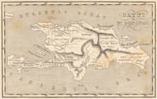
Map of Hispaniola. Hayti or S…
Map of the U. S. and Territor…
collection:
… of the
West
India Islands
Oud-Groenland, of deszelfs Oost-en
West
Kust
…., Essex Ave.,
West
Orange]
… of
West
Orange]
… of
West
Orange]
… of
West
Orange]
A general map of the southern…
collection:
… and
West
Florida, & ca
…,
West
Broadway]
….,
West
St., S. Orange Ave
Design map of the village of …
note:
… 1890 ; P.
R
. Jones, del.
indemere", Residence of
R
. M. Choaye
collection:
…", Residence of
R
. M. Choaye
m
….,
West
St.]
America noviter delineata
note:
Wagner, H.
R
. Cartography of the northwest
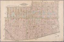
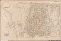
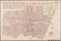
Plate 2: Bounded by
West
Street, (Hudson
… Street,
West
Street
…, Avenue
R
., W. 5th Street
m
…, Washington and
West
Streets
note:
… from Van
R
. Richmond
Carte d'un tres grand pais no…
note:
Wagner, H.
R
. Cartog. NW coast, II, 452
Amerique septentrionale
note:
Described in: Wagner, H.
R
. Cartography
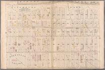
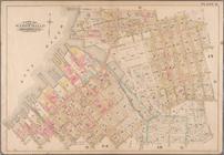
Plate 3: Bounded by
West
Street (Hudson
Plate 4:
West
Broadway, Canal Street
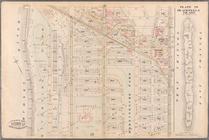
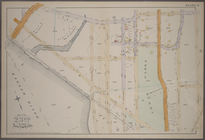
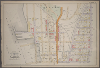
…, Central Park
West
(Eighth
…, Central Park
West
, and W
…, (Eighth Avenue)
West
…, Forest Avenue,
West
…., Railroad Ave.
West
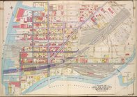
Queens, Vol. 2, Double Page P…
collection:
…., Pennsylvania
R
.
R
.]
…'s Island
West
(Harbors
note:
… the direction of F.
R
. Hassler
… &
West
Virginia
note:
… to
R
. Pearsall Smith
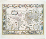
Nova totius terrarum orbis ge…
note:
Wagner, H.
R
. Cartog. NW coast, 320
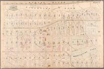
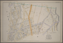
Plate 10: Bounded by
West
Street (Hudson
Plate 11: [Bounded by Noble S…
collection:
…, Quay Street and
West
….
West
, and Sedgwick Ave.]
… St.,
West
Farms Road
Map of the U. S. and Territor…
collection:
… of the
West
India Islands