Click to visit the main New York Public Library Homepage
The New York Public Library
Digital Collections
About Digital Collections
Browse
Search only public domain materials
Items
Collections
Divisions
Home
Search
Browse
About
Search only public domain materials
Items
Collections
Divisions
Digital Collections
Using Images
Using Data
Collections
Aphricae Tabula I
Aphricae Tabula I
About
Filters
Collection Data
Description
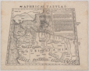
Ptolemic map of northern Africa, edited by Sebastian Münster. There is a large drawing of a ship in the Mediterranean. Mauritania is written in bold letters in the center of the map.
Names
Ptolemy, active 2nd century
(Artist)
Münster, Sebastian, 1489-1552
(Associated name)
Dates / Origin
Date Issued:
1550
(Questionable)
Place:
Basle
Library locations
Schomburg Center for Research in Black Culture, Jean Blackwell Hutson Research and Reference Division
Shelf locator: Sc Map N-95
Genres
Maps
Notes
Content: On verso: Text within border "Aphricae Tabula prima."
Content: Relief is shown by hachures. Mountains are shown by overlapping cones.
Physical Description
Extent: 36 x 26 cm.
Type of Resource
Cartographic
Identifiers
NYPL catalog ID (B-number):
b16097242
Universal Unique Identifier (UUID): 2c4e48f0-ee88-0131-58e3-58d385a7b928
Show filters
Hide filters
Show Only Public Domain
name
Münster, Sebastian, 1489-1552
1
Ptolemy, active 2nd century
1
collection
x
Aphricae Tabula I
genre
Maps
1
division
Schomburg Jean Blackwell Hutson Research and Reference Division
1
type
cartographic
1
Date Range
to
1 result found
Sort by:
Title
Date created
Date digitized
Sequence
Aphricae Tabula I