Click to visit the main New York Public Library Homepage
The New York Public Library
Digital Collections
About Digital Collections
Browse
Search only public domain materials
Items
Collections
Divisions
Home
Search
Browse
About
Search only public domain materials
Items
Collections
Divisions
Digital Collections
Using Images
Using Data
Collections
Charting America: Maps from the Lawrence H. Slaughter Collection and Others
Charting America: Maps from the Lawrence H. Slaughter Collection and Others
Navigation
Filters
Charting America: Maps from the Lawrence H. Slaughter Collection and Others
Previous
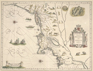
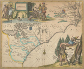
The south part of Virginia, now the north part of Carolina
0
Atlases, gazetteers, guidebooks and other books
377
Maps of the World
16
Maps of the Oceans
24
Maps of North and South America
23
Maps of North America.
551
Maps of New York City and State
1340
Lawrence H. Slaughter Collection of English maps, charts, globes, books and atlases
1020
John H. Levine Collection
60
More
Show filters
Hide filters
Show Only Public Domain
name
Blaeu, Willem Janszoon, 1571-1638
2
Blaeu, Joan, 1596-1673
1
Groux
1
Hondius, Hendrik, 1597-1651
1
Hondius, Jodocus, 1563-1612
1
More
Less
collection
x
John H. Levine Collection
place
Florida
2
South Atlantic States
2
Virginia
2
Georgia
1
New England -- Maps -- Early works to 1800
1
More
Less
genre
Maps
5
publisher
Apud Guiljelmum Blaeuw? ,
1
H. Hondius?
1
J. Meurs?,
1
J. and C. Blaeu
1
s.n
1
division
Map Division
5
type
cartographic
5
Date Range
to
5 results found for:
x
South Atlantic States
Filtering on:
x
Collection
: John H. Levine Collection
Sort by:
Relevance
Title
Date created
Date digitized
Sequence
Nova Belgica et Anglia Nova.
note:
Shows New England
south
to Cape Henry
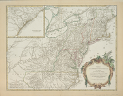
Partie de l'Amerique septentr…
note:
… to
South
Carolina and from the
Atlantic
coast
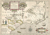
Virginiae item et Floridae Am…
note:
…
Atlantic
Seaboard.
Virginiae partis australis, e…
note:
Covers
Atlantic
Coast from Virginia
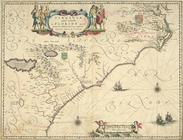
Virginiae partis australis, e…
note:
Covers the
Atlantic
coast from the mouth