Click to visit the main New York Public Library Homepage
The New York Public Library
Digital Collections
About Digital Collections
Browse
Search only public domain materials
Items
Collections
Divisions
Home
Search
Browse
About
Search only public domain materials
Items
Collections
Divisions
Digital Collections
Using Images
Using Data
Collections
Charting America: Maps from the Lawrence H. Slaughter Collection and Others
Charting America: Maps from the Lawrence H. Slaughter Collection and Others
Navigation
Filters
Charting America: Maps from the Lawrence H. Slaughter Collection and Others
Previous
The south part of Virginia, now the north part of Carolina
0
Atlases, gazetteers, guidebooks and other books
377
Maps of the World
16
Maps of the Oceans
24
Maps of North and South America
23
Maps of North America.
551
Maps of New York City and State
1340
Lawrence H. Slaughter Collection of English maps, charts, globes, books and atlases
1020
John H. Levine Collection
60
More
Show filters
Hide filters
Show Only Public Domain
topic
x
Coasts
Nautical charts
4
Atlases, British
2
West Indies, British
2
name
Des Barres, Joseph F. W. (Joseph Frederick Wallet), 1729-1824
2
Godbid, Anne
2
Playford, John, ca. 1655-1685 or 6
2
Seller, John, fl. 1658-1698
2
France. Dépôt des cartes et plans de la marine
1
More
Less
collection
Lawrence H. Slaughter Collection of English maps, charts, globes, books and atlases
6
John H. Levine Collection
1
place
Atlantic Coast (North America)
4
Caribbean Area
4
Mexico, Gulf of
3
West Indies
3
Central America
2
More
Less
genre
Maps
7
publisher
Printed by A. Godbid and J. Playford, for John Seller ...,
2
Published for the use of the Royal Navy of Great Britain by Joseph F. W. Des Barres
2
Depot general de la marine
1
Johanne van Keulen
1
s.n.,
1
division
Map Division
7
type
cartographic
7
Date Range
to
7 results found for:
x
Atlantic Coast (North America)
Filtering on:
x
Topic
: Coasts
Sort by:
Relevance
Title
Date created
Date digitized
Sequence
m
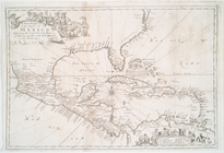
A chart of the West Indias fr…
note:
…
Atlantic
Seaboard.
m
A chart of the West Indias fr…
note:
…
Atlantic
Seaboard.
… the islands in the
North
Sea
note:
Also covers
Atlantic
coast
of Virginia
Pas kaart van West Indien : b…
note:
…
coast
of
North
America
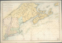
[A chart of New York Island &
North
note:
Covers the
coast
of Long Island from Eaton
A chart of New York Island &
North
River
note:
Covers the
coast
of Long Island from Eaton
Carte réduite des côtes orien…
note:
LC Maps of
North
America
, 1750-1789, 215