Click to visit the main New York Public Library Homepage
The New York Public Library
Digital Collections
About Digital Collections
Browse
Search only public domain materials
Items
Collections
Divisions
Home
Search
Browse
About
Search only public domain materials
Items
Collections
Divisions
Digital Collections
Using Images
Using Data
Collections
Charting America: Maps from the Lawrence H. Slaughter Collection and Others
Charting America: Maps from the Lawrence H. Slaughter Collection and Others
Navigation
Filters
Charting America: Maps from the Lawrence H. Slaughter Collection and Others
Previous
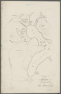
The south part of Virginia, now the north part of Carolina
0
Atlases, gazetteers, guidebooks and other books
377
Maps of the World
16
Maps of the Oceans
24
Maps of North and South America
23
Maps of North America.
551
Maps of New York City and State
1340
Lawrence H. Slaughter Collection of English maps, charts, globes, books and atlases
1020
John H. Levine Collection
60
More
Show filters
Hide filters
Show Only Public Domain
topic
Road maps
53
Geography
33
History
30
Nautical charts
22
Harbors
16
More
Less
name
Colles, Christopher, 1738-1816
54
Tiebout, Cornelius, 1777-1832
54
Mitchell, S. Augustus (Samuel Augustus), 1792-1868
28
Morse, Jedidiah, 1761-1826
27
Stockdale, John, 1749?-1814
27
More
Less
collection
Lawrence H. Slaughter Collection of English maps, charts, globes, books and atlases
177
Maps of New York City and State
106
Atlases, gazetteers, guidebooks and other books
36
John H. Levine Collection
8
Maps of North and South America
3
More
Less
place
United States
184
Middle Atlantic States
72
New York (State)
72
New York (N.Y.)
31
North America
20
More
Less
genre
Maps
307
Registers (Lists)
23
Nautical charts
10
Facsimiles
5
Bathymetric maps
4
More
Less
publisher
S. A. Mitchell, jr
28
Printed for J. Stockdale
26
M. Carey
17
Printed by H. Sweitzer, for M. Carey,
7
The Survey
6
More
Less
division
Map Division
330
Manuscripts and Archives Division
1
type
cartographic
304
text
27
still image
1
Date Range
to
332 results found for:
United States
Sort by:
Relevance
Title
Date created
Date digitized
Sequence
Results 251 - 300
…
United
Association. List
m
Flushing Bay, Long Island, N.…
note:
…"
United
States
Engineer Office, District
m
Map of New-York Bay and Harbo…
note:
… of the Coast of the
United
States
; triangulation
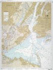
New York Harbor and entrance …
collection:
Maps of New York City and
State
m
Map of New-York Bay and Harbo…
note:
… of the Coast of the
United
States
; triangulation
Map of New-York Bay and Harbo…
note:
… of the Coast of the
United
States
; triangulation
Map of New-York Bay and Harbo…
note:
… of the Coast of the
United
States
; triangulation
Sketch illustrating the progr…
collection:
Maps of New York City and
State
Hell Gate and its approaches
note:
… of the Coast of the
United
States
.
m
United
States
--east coast, New York--New
note:
… and Geodetic Survey.|t
United
States
--east coast, New
Map of the port & vicinity of…
collection:
Maps of New York City and
State
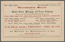
m
… by order of the
United
State
Mortgage and Trust
Asher & Adams' map of the bay…
collection:
Maps of New York City and
State
G. Woolworth Colton's new map…
note:
… Court of the
United
States
for the Southern
G. Woolworth Colton's new map…
note:
… Court of the
United
States
for the Southern
m
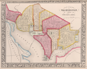
Map of the metropolitan distr…
note:
… are due to the
United
States
Geological Survey
Colton's New York City, Brook…
note:
… of the
United
States
Map and profile showing sourc…
collection:
Maps of New York City and
State
Plan of the position taken by…
collection:
Maps of New York City and
State
A topographical map of the no…
collection:
Maps of New York City and
State
Operations on the Hudson River
collection:
Maps of New York City and
State
Operations on Hudson's River
collection:
Maps of New York City and
State
Plan of the Battle of Long Is…
collection:
Maps of New York City and
State
Map of Brooklyn at the time o…
collection:
Maps of New York City and
State
Attack on forts Clinton and M…
collection:
Maps of New York City and
State
Position of the American Army…
collection:
Maps of New York City and
State
Battle of Long Island: from S…
collection:
Maps of New York City and
State
A sketch of the operations of…
collection:
Maps of New York City and
State
Map of New York City and of M…
collection:
Maps of New York City and
State
Plan von den Operationen der …
collection:
Maps of New York City and
State
Position de l'armée Américain…
collection:
Maps of New York City and
State
Plan of the position which th…
collection:
Maps of New York City and
State
A sketch of the siege of Fort…
collection:
Maps of New York City and
State
Works at Stony Point and Verp…
collection:
Maps of New York City and
State
Grundriss des nördlichen Thei…
collection:
Maps of New York City and
State
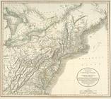
A new map of part of the
United
States
of North
topic:
Middle Atlantic
States
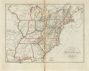
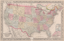
Map of the
United
States
of America
… territories of the
United
States
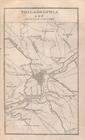
New York and adjacent country.
collection:
… description of the
United
States
Philadelphia and adjacent cou…
collection:
… description of the
United
States
Baltimore, Annapolis, and adj…
collection:
… description of the
United
States
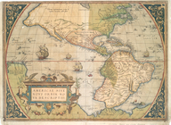
Americae sive novi orbis, nov…
note:
Ermen, E. van.
United
States
in old maps
Map of the
United
States
, and territories
… of the
United
States
of America.
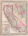
County map California; Map of…
note:
… of the
United
States
.]
… Offices in the
United
States
. [A, B]
… Offices in the
United
States
. [B]
… Offices in the
United
States
. [B, C]
… Offices in the
United
States
. [C]
… Offices in the
United
States
. [C, D]
1
2
Previous
Next
1
2
Previous
Next