Spezialkarte der Osterreichisch-Ungarischen Monarchie

Collection Data

Description
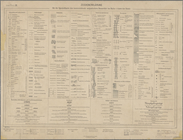
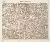
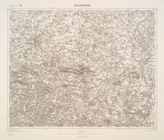
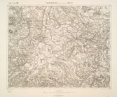
Over 700 topographic maps of the Austro-Hungarian Empire, surveyed between 1877-1914 and published together as a collection. Editions vary. Relief shown by hachures and spot heights. Each map individually named and numbered with zone and column numbers. Includes index map. Zeichenerklärung (legend) on sheet numbered zone 1 kol. IX.
Names
Austro-Hungarian Monarchy. Militärgeographisches Institut (Cartographer)
Dates / Origin
Date Issued: 1877 - 1914
Place: Vienna
Publisher: K.u.K. Militargeographisches Institut
Library locations
Lionel Pincus and Princess Firyal Map Division
Shelf locator: Map Div. 04-336
Topics
Austria
Hungary
Historical geography
Genres
Maps
Topographic maps
Notes
Source note: Description based on: "Ubersichtsblatt," 1916.
Physical Description
Extent: 776 maps ; 38 x 55 cm. or smaller
Engravings
Type of Resource
Cartographic
Text
Identifiers
RLIN/OCLC: 22951454
NYPL catalog ID (B-number): b15888873
Universal Unique Identifier (UUID): 1fa2d5b0-c5ef-012f-fa0d-58d385a7bc34
Show filters Hide filters
774 results found