Click to visit the main New York Public Library Homepage
The New York Public Library
Digital Collections
About Digital Collections
Browse
Search only public domain materials
Items
Collections
Divisions
Home
Search
Browse
About
Search only public domain materials
Items
Collections
Divisions
Digital Collections
Using Images
Using Data
Collections
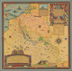
The great war map of battle line in France and Belgium
The great war map of battle line in France and Belgium
About
Filters
Collection Data
Description
The great war map of battle line in France and Belgium on the 25th of September 1918. The exact position of the allies and central powers are taken from a plan compiled for the British war records under the supervision of Field Marshal Lord Haig.
Names
Clegg, Ernest
(Cartographer)
Haig, Douglas, Sir, 1861-1928
(Contributor)
Allied Map Company
(Publisher)
Dates / Origin
Date Issued:
1926
Place:
New York
Publisher:
Allied Map Corp.
Library locations
Rare Book Division
Shelf locator: *KVB+++ 1926 n.c.
Topics
World War, 1914-1918
Genres
Maps
Broadsides
Notes
Statement of responsibility: Designed and drawn by Ernest Clegg.
Additional physical form: Another copy, not colored, in Map Division; positive and negative photostats in Map Division.
Physical Description
Lithographs
Extent: 1 sheet: 26 1/4 x 26 1/4 in.
Scale: 1 inch = 14 miles.
Colored. Printed on cloth
Type of Resource
Cartographic
Identifiers
Photo Order: 59150
Universal Unique Identifier (UUID): caa90ec0-31d6-0136-5170-57c36f88a6be
Show filters
Hide filters
Show Only Public Domain
topic
World War, 1914-1918
1
name
Allied Map Company
1
Clegg, Ernest
1
Haig, Douglas, Sir, 1861-1928
1
collection
x
The great war map of battle line in France and Belgium
genre
Broadsides
1
Maps
1
publisher
Allied Map Corp
1
division
Rare Book Division
1
type
cartographic
1
Date Range
to
1 result found
Sort by:
Title
Date created
Date digitized
Sequence
The great war map of battle l…