+ o - ^
previous next

Karte von einem Theile des Eis Meeres nach Mercatos Projection: Zusamengesetzt u. beschrieben von den Lieutenants Wrangel u. Anjou in den Jahren 1821, 1822 u. 1823

More Details Cite This Item

View this item elsewhere:

Title
Karte von einem Theile des Eis Meeres nach Mercatos Projection: Zusamengesetzt u. beschrieben von den Lieutenants Wrangel u. Anjou in den Jahren 1821, 1822 u. 1823
Names
Wrangel, Ferdinand Petrovich, baron, 1796-1870 (Author)
Parrot, Georg Friedrich, 1767-1852 (Author)
Mare, C. (Attributed name)
Collection

Physikalische Beobachtungen des Capitain-Lieutenant Baron v. Wrangel wahrend seiner Reisen auf dem Eismeere in den Jahren 1821, 1822 und 1823

Dates / Origin
Date Issued: 1827
Place: Berlin
Publisher: G. Reimer
Library locations
General Research Division
Shelf locator: KBM (Wrangel, F. P. Physikalische Beobachtungen)
Topics
Arctic regions
Siberia, Northeastern (Russia)
Arctic Ocean
Genres
Illustrations
Type of Resource
Still image
Languages
German
Identifiers
NYPL catalog ID (B-number): b13023018
Universal Unique Identifier (UUID): e9c9c9b0-0162-013b-6f60-0242ac110002
Rights Statement
The New York Public Library believes that this item is in the public domain under the laws of the United States, but did not make a determination as to its copyright status under the copyright laws of other countries. This item may not be in the public domain under the laws of other countries. Though not required, if you want to credit us as the source, please use the following statement, "From The New York Public Library," and provide a link back to the item on our Digital Collections site. Doing so helps us track how our collection is used and helps justify freely releasing even more content in the future.

Item timeline of events

  • 1796: Creator Born
  • 1827: Issued
  • 1870: Creator Died
  • 2023: Digitized
  • 2024: Found by you!
  • 2025

MLA Format

General Research Division, The New York Public Library. "Karte von einem Theile des Eis Meeres nach Mercatos Projection" The New York Public Library Digital Collections. 1827. https://digitalcollections.nypl.org/items/0e419d90-0163-013b-b3b1-0242ac110002

Chicago/Turabian Format

General Research Division, The New York Public Library. "Karte von einem Theile des Eis Meeres nach Mercatos Projection" New York Public Library Digital Collections. Accessed April 24, 2024. https://digitalcollections.nypl.org/items/0e419d90-0163-013b-b3b1-0242ac110002

APA Format

General Research Division, The New York Public Library. (1827). Karte von einem Theile des Eis Meeres nach Mercatos Projection Retrieved from https://digitalcollections.nypl.org/items/0e419d90-0163-013b-b3b1-0242ac110002

Wikipedia Citation

<ref name=NYPL>{{cite web | url=https://digitalcollections.nypl.org/items/0e419d90-0163-013b-b3b1-0242ac110002 | title= (still image) 
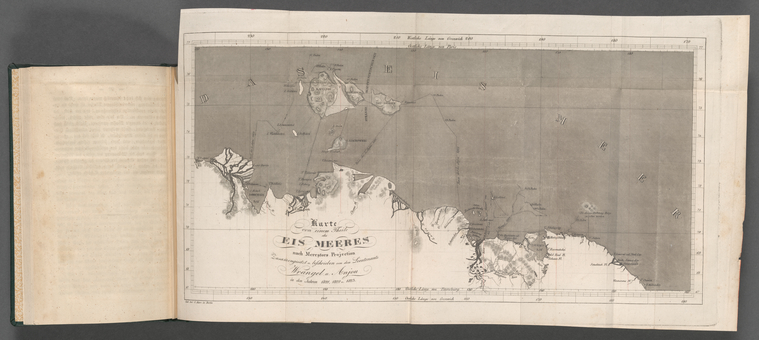
Karte von einem Theile des Eis Meeres nach Mercatos Projection, (1827) |author=Digital Collections, The New York Public Library |accessdate=April 24, 2024 |publisher=The New York Public Library, Astor, Lenox, and Tilden Foundations}}</ref>

Karte von einem Theile des Eis Meeres nach Mercatos Projection