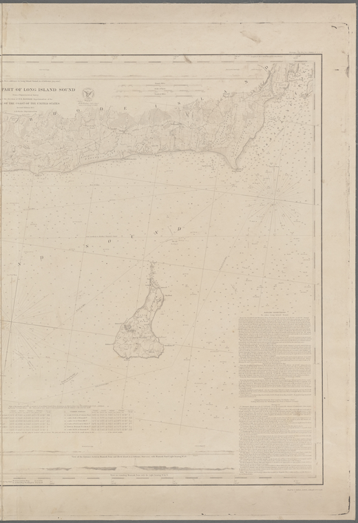
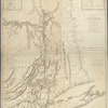
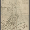
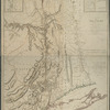
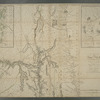
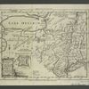
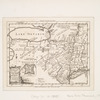
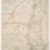
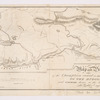
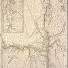
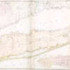
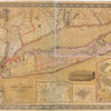
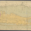
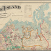
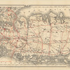
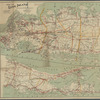
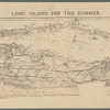
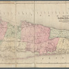
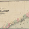
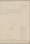
TitleEastern part of Long Island Sound
NamesUnited States Coast Survey (Issuing body)Hassler, F. R. (Ferdinand Rudolph), 1770-1843 (Creator)Bache, A. D. (Alexander Dallas), 1806-1867 (Creator)Benham, Henry Washington, 1813-1884 (Creator)Mathiot, G. (Creator)Siebert, Selmar (Engraver)Rollé, A. (Engraver)Knight, John, approximately 1802-1872 (Engraver)
CollectionMaps of New York City and State
Parts
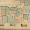
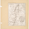
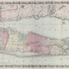
Long Island
Dates / OriginDate Issued: 1855Place: Washington, D.C.Publisher: U.S. Coast Survey officeEdition: Second edition
Library locationsLionel Pincus and Princess Firyal Map DivisionShelf locator: Map Div. 16-733
TopicsNautical charts -- Long Island Sound (N.Y. and Conn.)Nautical charts -- New York (State) -- Suffolk CountyNautical charts -- Rhode Island -- Block Island (Island)Nautical charts -- Connecticut -- Atlantic CoastNautical charts -- New York (State) -- Long Island (N.Y.)Nautical charts -- New York (State) -- MontaukCoasts -- ConnecticutLong Island Sound (N.Y. and Conn.)
GenresMapsNautical charts
NotesStatement of responsibility: From a trigonometrical survey under the direction of F.R. Hassler, superintendent of the Survey of the Coast of the United States ; A.D. Bache, Superintendent ; engd. by S. Siebert, A Rollé, J. Knight, & W. Smith.Statement of responsibility: "Verified, H.W. Benham, capt. of engrs. asst. C.S. in charge of office."Statement of responsibility: "Electrotype Copy No. 6 by G. Mathiot, U.S.C.S."--top right margin.Funding: Mapping the Nation (NEH grant, 2015-2018)
Physical DescriptionExtent: 1 map ; 64 x 87 cm, folded in cover 18 x 12 cm
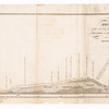
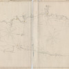
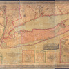
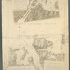
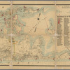
DescriptionIncludes charts of tides, bottom types, light houses, current stations, text of sailing directions and dangers. Also includes 4 panoramic views: View of the Race entrance to Long Island Sound in 14 fathoms, (grey sand) -- View between Montauk Point and Block Island in 25 fathoms (black mudd), with Montauk Fixed Light bearing W. 1/2 N. -- Montauk Fixed Light : view in 9 fathoms (N.W. by N. 1/2 N.) -- View on round Montauk Point with light bearing W. by S. Relief shown by hachures and landform drawings. Depths shown by soundings. Prime meridians: New York and Greenwich. Incomplete coordinates: E 0°57ʹ--E 1°46ʹ. "No. 114"--top left margin. "Sheet no. 3" -- center left margin. "Published in 1855."
Type of ResourceCartographic
IdentifiersRLIN/OCLC: 137349615NYPL catalog ID (B-number): b20920523Folder number: US160.1.03Photo Order: 58243Universal Unique Identifier (UUID): 45ed47e0-793c-0135-6bfd-47d71542dbac
Rights StatementThe New York Public Library believes that this item is in the public domain under the laws of the United States, but did not make a determination as to its copyright status under the copyright laws of other countries. This item may not be in the public domain under the laws of other countries. Though not required, if you want to credit us as the source, please use the following statement, "From The New York Public Library," and provide a link back to the item on our Digital Collections site. Doing so helps us track how our collection is used and helps justify freely releasing even more content in the future.
Item timeline of events
-
-
-
-