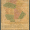
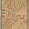
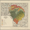
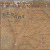
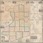
TitleMap of Erie County, New York: from actual surveys
NamesGeil, Samuel (Cartographer)Smith, Robert Pearsall, 1827-1898 (Associated name)Gillette, Matthews & Co. (Publisher)
CollectionMaps of New York City and State
Counties
Dates / OriginDate Issued: 1855Place: PhiladelphiaPublisher: Gillette Matthews & Co, Publishers
Library locationsLionel Pincus and Princess Firyal Map DivisionShelf locator: Map Div. 16-5985
TopicsLandowners -- New York (State) -- Erie CountyReal property -- New York (State) -- Erie CountyErie County (N.Y.)New York (State) -- Erie County
GenresMapsCadastral maps
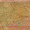
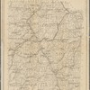
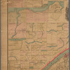
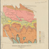
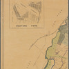
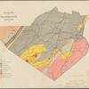
NotesStatement of responsibility: by Samuel Geil, author of maps of Niagara, Orleans & Cayuga Counties, N.Y., &c.Content: Shows landowners.Statement of responsibility: "Entered according to act of Congress in the year 1855 by Robert Pearsall Smith..."Content: Includes "A map of the City of Buffalo," ancillary maps, statistical chart, business directories, and illustrations.Content: Ancillary maps: Abbott's Corners or Hamburg P.O. -- Akron -- Alden -- Boston -- Bowmansville -- Clarence -- Clarence Centre -- Colden -- Collins Centre -- East Aurora -- East Hamburg -- Eden -- Elma -- Evans Centre -- Evans Station -- Fallkirk -- Gowanda -- Griffins Mills -- Holland Village -- Lancaster -- Marilla Center -- Plan of North Collins -- Pontiac -- Sardinia -- South Wales -- Springville -- Tonawanda Village from actual survey / by Tobias Witmer of Amherst -- Wales Center -- Wales Hollow -- West Falls -- Whites Corners -- Williamsville.Funding: Mapping the Nation (NEH grant, 2015-2018)
Physical DescriptionExtent: 1 map : hand colored ; 125 x 93 cm, on sheet 142 x 143 cm
Type of ResourceCartographic
IdentifiersLibrary of Congress Control Number: 2012593658RLIN/OCLC: 850845611NYPL catalog ID (B-number): b20645812Other local Identifier: US164.1.04Universal Unique Identifier (UUID): 3042bb10-cd15-0133-269f-00505686a51c
Rights StatementThe New York Public Library believes that this item is in the public domain under the laws of the United States, but did not make a determination as to its copyright status under the copyright laws of other countries. This item may not be in the public domain under the laws of other countries. Though not required, if you want to credit us as the source, please use the following statement, "From The New York Public Library," and provide a link back to the item on our Digital Collections site. Doing so helps us track how our collection is used and helps justify freely releasing even more content in the future.
Item timeline of events
-
-
-
-