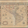
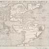
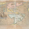
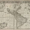
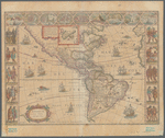
TitleAmericae nova tabula
Additional title: Threatrum orbis terrarum
NamesBlaeu, Willem Janszoon, 1571-1638 (Cartographer)White, John, fl. 1585-1593 (Artist)Blaeu, Joan, 1596-1673 (Publisher)
CollectionMaps of North and South America
Whole
Dates / OriginDate Issued: 1635Place: AmsterdamPublisher: Joan Blaeu
Library locationsLionel Pincus and Princess Firyal Map DivisionShelf locator: Map Div. 15-5008 Filed with North and South America [1635]]
TopicsIndians of North AmericaWestern HemisphereAmericaAmerica -- Discovery and exploration
GenresMaps
NotesStatement of responsibility: auct: Guiljelmo Blaeuw.Content: Scale approximately 1:45,000,000 (W 171°54ʹ00ʺ--W 5°37ʹ00ʺ/N 77°01ʹ00ʺ--S 60°00ʹ00ʺ)Content: Includes latitude and longitude.Content: "Cum privilegio decem annorum."Content: Illustrated with sea monsters and ships bearing different flags.Content: Shows North and South America, the western tips of Europe and Africa in the east.Content: Decorative borders depict nine town plans along the top, including Havana, Santo Domingo, Cartegena, Mexico City and Rio de Janeiro, in addition to ten vignettes of Native American figures along left and right border.Content: Inset: Greenland and Iceland.Content: Includes a description of Greenland and Iceland near inset.Content: Latin text with signature "America A", catchword "nis" and "I" in upper right on versoFunding: Mapping the Nation (NEH grant, 2015-2018)
Physical DescriptionExtent: 1 map : hand colored ; 41 x 56 cm, on sheet 50 x 59 cmRelief shown pictoriallyAccession number 53553 stamp in ink at lower left
Type of ResourceCartographicText
LanguagesLatin
IdentifiersRLIN/OCLC: 858870403NYPL catalog ID (B-number): b20643236Other local Identifier: NA001.4.03Universal Unique Identifier (UUID): 3516bae0-f8c8-0132-d977-58d385a7bbd0
Rights StatementThe New York Public Library believes that this item is in the public domain under the laws of the United States, but did not make a determination as to its copyright status under the copyright laws of other countries. This item may not be in the public domain under the laws of other countries. Though not required, if you want to credit us as the source, please use the following statement, "From The New York Public Library," and provide a link back to the item on our Digital Collections site. Doing so helps us track how our collection is used and helps justify freely releasing even more content in the future.
Item timeline of events
-
-
-
-
-
-