


- The Library Shop
- Privacy Policy
- Rules and Regulations
- Using the Internet
- Website Terms and Conditions
- Gifts of Materials to NYPL
-
© The New York Public Library, 2024
The New York Public Library is a 501(c)(3) | EIN 13-1887440

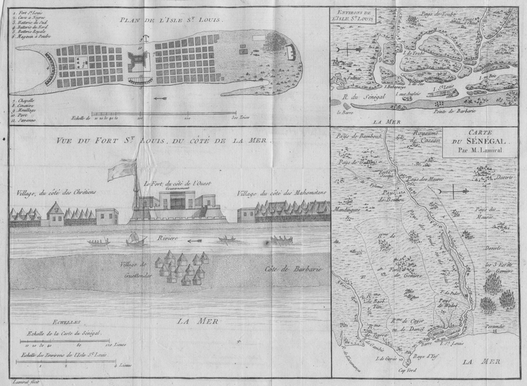
Schomburg Center for Research in Black Culture, Manuscripts, Archives and Rare Books Division, The New York Public Library. "1. Plan de L'Isle St. louis, 2. Environs de L'Isle St. Louis, 3. Vue du Fort St. Louis, du Cote de la Mer, 4. Carte du Senegal." The New York Public Library Digital Collections. 1789. https://digitalcollections.nypl.org/items/510d47da-6e6c-a3d9-e040-e00a18064a99
Schomburg Center for Research in Black Culture, Manuscripts, Archives and Rare Books Division, The New York Public Library. "1. Plan de L'Isle St. louis, 2. Environs de L'Isle St. Louis, 3. Vue du Fort St. Louis, du Cote de la Mer, 4. Carte du Senegal." New York Public Library Digital Collections. Accessed April 24, 2024. https://digitalcollections.nypl.org/items/510d47da-6e6c-a3d9-e040-e00a18064a99
Schomburg Center for Research in Black Culture, Manuscripts, Archives and Rare Books Division, The New York Public Library. (1789). 1. Plan de L'Isle St. louis, 2. Environs de L'Isle St. Louis, 3. Vue du Fort St. Louis, du Cote de la Mer, 4. Carte du Senegal. Retrieved from https://digitalcollections.nypl.org/items/510d47da-6e6c-a3d9-e040-e00a18064a99
<ref name=NYPL>{{cite web | url=https://digitalcollections.nypl.org/items/510d47da-6e6c-a3d9-e040-e00a18064a99 | title=
(still image)
1. Plan de L'Isle St. louis, 2. Environs de L'Isle St. Louis, 3. Vue du Fort St. Louis, du Cote de la Mer, 4. Carte du Senegal., (1789)
|author=Digital Collections, The New York Public Library |accessdate=April 24, 2024 |publisher=The New York Public Library, Astor, Lenox, and Tilden Foundations}}</ref>
