


![New reservoir. [Order creating commission to obtain land for the reservoir.]](https://images.nypl.org/index.php?id=1648986&t=b)

![Index: Borough of Manhattan. Scale 1800 feet to the Inch. LEGEND, [Battery Park - 158th Street].](https://images.nypl.org/index.php?id=1512204&t=b)
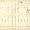
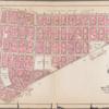
![Plate 1: Bounded by Liberty Street, Maiden Lane, [East River, Piers 1-14] South Street, Battery Park, and [Hudson River, Piers 2-37] West Street.]](https://images.nypl.org/index.php?id=1512205&t=b)
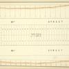
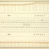
![Plate 2: Bounded by Jay Street, Hudson Street, Thomas Street, Pearl Street, Park Row, N. William Street, William street, Liberty Street, and [Hudson River, Piers 13-22]West Street.]](https://images.nypl.org/index.php?id=1512206&t=b)
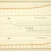
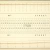
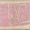
![Plate 3: Bounded by William Street, N. William Street, Park Row, Chatham Square, Market Street, Market Slip, [Hudson River, Piers 15-29] South Street, and Liberty Street.]](https://images.nypl.org/index.php?id=1512201&t=b)
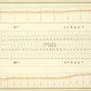
![Plate 6: Bounded by Division Street, Grand Street, Corlears Street, Cherry Street, Jackson Street, [East River, Piers 29-54] South Street, Market Slip, and Market Street.]](https://images.nypl.org/index.php?id=1512207&t=b)
![Plate 7: Bounded by E. 3rd Street, [East River, Piers 60-64] Tompkins Street, [East River, Piers 55-60] East Street, Water Street, Corlears Street, Grand Street, Attorney Street, Essex Street, and Avenue A.]](https://images.nypl.org/index.php?id=1512213&t=b)
![Plate 9: Bounded by Charles Street, Washington Street, W. 10th Street, Hudson Street, Christopher Street, Bedford Street, Barrow Street, Bleecker Street, Cornelia Street, Sixth Avenue, W. 3rd Street, W. Broadway, Broome Street, Hudson Street, Spring Street, and [Hudson River, Piers 35-47] West Street.]](https://images.nypl.org/index.php?id=1512218&t=b)
![Plate 10: Bounded by W. 14th Street, Sixth Avenue, Cornelia Street, Bleecker Street, Barrow Street, Bedford Street, Christopher Street, Hudson Street, W. 10th Street, Washington Street, Charles Street, and [Hudson River, Piers 48-55] West Street.]](https://images.nypl.org/index.php?id=1512219&t=b)
- The Library Shop
- Privacy Policy
- Rules and Regulations
- Using the Internet
- Website Terms and Conditions
- Gifts of Materials to NYPL
-
© The New York Public Library, 2024
The New York Public Library is a 501(c)(3) | EIN 13-1887440
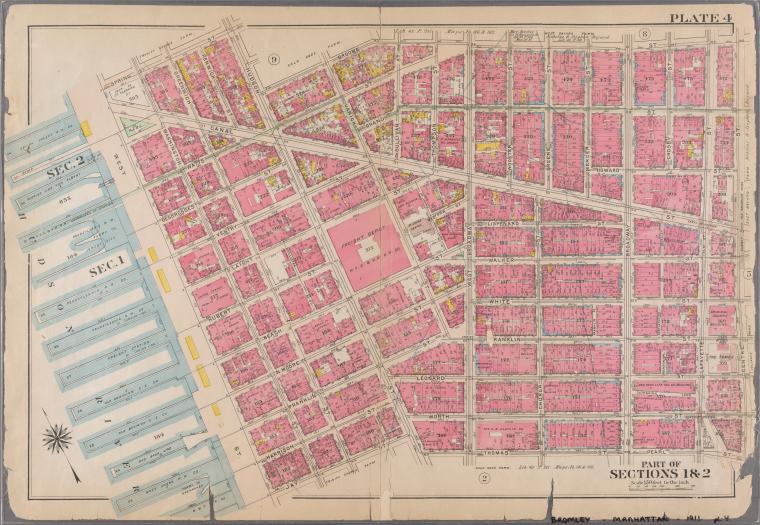
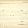
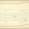
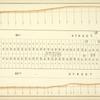
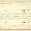
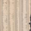
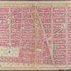
![Plate 4: Bounded by Spring Street, Hudson Street, Broome Street, Centre Street, Pearl Street, Thomas Street, Hudson Street, Jay Sreet and [Hudson River, Piers 22-34] West Street.]](https://images.nypl.org/index.php?id=1512216&t=b)
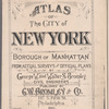
Atlas of the city of New York, borough of Manhattan. From actual surveys and official plans [1911]
Lionel Pincus and Princess Firyal Map Division, The New York Public Library. "Plate 4: Bounded by Spring Street, Hudson Street, Broome Street, Centre Street, Pearl Street, Thomas Street, Hudson Street, Jay Sreet and [Hudson River, Piers 22-34] West Street.]" The New York Public Library Digital Collections. 1911. https://digitalcollections.nypl.org/items/510d47e2-095b-a3d9-e040-e00a18064a99
Lionel Pincus and Princess Firyal Map Division, The New York Public Library. "Plate 4: Bounded by Spring Street, Hudson Street, Broome Street, Centre Street, Pearl Street, Thomas Street, Hudson Street, Jay Sreet and [Hudson River, Piers 22-34] West Street.]" New York Public Library Digital Collections. Accessed April 20, 2024. https://digitalcollections.nypl.org/items/510d47e2-095b-a3d9-e040-e00a18064a99
Lionel Pincus and Princess Firyal Map Division, The New York Public Library. (1911). Plate 4: Bounded by Spring Street, Hudson Street, Broome Street, Centre Street, Pearl Street, Thomas Street, Hudson Street, Jay Sreet and [Hudson River, Piers 22-34] West Street.] Retrieved from https://digitalcollections.nypl.org/items/510d47e2-095b-a3d9-e040-e00a18064a99
<ref name=NYPL>{{cite web | url=https://digitalcollections.nypl.org/items/510d47e2-095b-a3d9-e040-e00a18064a99 | title=
(cartographic)
Plate 4: Bounded by Spring Street, Hudson Street, Broome Street, Centre Street, Pearl Street, Thomas Street, Hudson Street, Jay Sreet and [Hudson River, Piers 22-34] West Street.], (1911)
|author=Digital Collections, The New York Public Library |accessdate=April 20, 2024 |publisher=The New York Public Library, Astor, Lenox, and Tilden Foundations}}</ref>
![Plate 4: Bounded by Spring Street, Hudson Street, Broome Street, Centre Street, Pearl Street, Thomas Street, Hudson Street, Jay Sreet and [Hudson River, Piers 22-34] West Street.]](https://images.nypl.org/index.php?id=1512216&t=t)